
Strong to Severe Storms With Damaging Winds and Heavy Rain Possible Across Ohio Including Dayton Richmond Celina and Springfield From 3PM to 11PM Tuesday
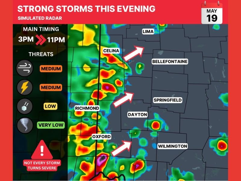
OHIO — Strong to severe storms are possible across Ohio this evening, May 19, 2026, with the main threat window running from 3 PM through 11 PM. Damaging winds are the primary concern rated at medium threat, alongside medium lightning threat and locally heavy rainfall. Hail carries a low threat while tornado potential remains very low for today’s storm setup across the region.
Not every storm today is expected to turn severe, but warnings could develop for isolated stronger cells as the evening progresses.
Damaging Winds and Heavy Rain Lead the Threat List From 3PM Through 11PM
Damaging winds and frequent lightning are rated as medium threats for this evening’s storm activity across the Ohio corridor from Richmond and Oxford northward through Celina and Lima. Locally heavy rainfall is also possible with the stronger storm cells tracking through the region during the evening hours.
Simulated radar shows storm activity tracking eastward across the western Ohio corridor with the most organized cells focused near Celina, Richmond, and Oxford during the peak evening window.
Hail Low and Tornado Very Low But Isolated Warnings Cannot Be Ruled Out
While hail and tornado potential are rated low and very low respectively for today’s event, the atmosphere remains unstable enough for isolated severe warnings to be issued if stronger cells develop. Residents across Dayton, Springfield, Bellefontaine, and Wilmington should remain weather aware through the evening hours even though widespread significant severe weather is not expected.
The simulated radar concept shows the storm line pushing eastward through western Ohio during the 3 PM to 11 PM window before gradually weakening overnight.
Weather Awareness Essential Across Western Ohio Through Late Evening
Anyone with outdoor plans across the Dayton, Richmond, Celina, and Springfield area Tuesday evening should monitor radar closely and be prepared to move indoors quickly if warnings are issued. The storm timing running through 11 PM means the evening hours carry the highest risk for any rapidly developing severe cells across the region. Stay with NapervilleLocal.com for the latest weather updates and local forecast coverage.

I’ve lived in Naperville long enough to see how quickly our community changes — from new developments downtown to sudden shifts in our Midwest weather. Reporting on Naperville news and daily forecasts gives me the chance to keep neighbors informed about what really matters. My goal is simple: deliver clear, timely updates so you always know what’s happening in our city and what to expect from the skies above.