
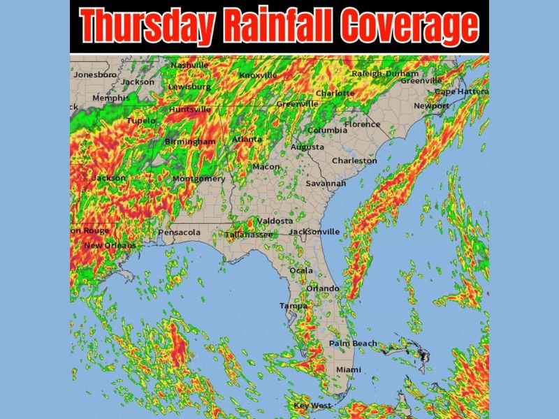
Widespread Rainfall Covering the Southeast From Memphis and Atlanta Through the Carolinas and Florida With Heaviest Coverage Across the Carolinas and Western Florida Peninsula Thursday
SOUTHEASTERN UNITED STATES — Widespread rainfall coverage is sweeping across the Southeast on Thursday, May 21, 2026, continuing a multi-day pattern that has been impacting the region for several consecutive days. The rainfall footprint stretches from Memphis and Jackson through Tennessee, Alabama, Georgia, the Carolinas, and down through the Florida peninsula, with the heaviest and most intense coverage concentrated across the Carolinas and the middle to western side of Florida.
Multi-Day Rainfall Pattern Continues Across the Broader Southeast Thursday
Thursday’s rainfall coverage follows the same general pattern that has been in place across the Southeast for the last several days, keeping the region in a persistently wet and active weather cycle. Areas from Jonesboro and Memphis eastward through Nashville, Knoxville, and into the Carolinas are all seeing continued rainfall activity with no meaningful dry break in sight.
The radar coverage map shows dense red and yellow rainfall signatures across Tennessee, Alabama, and Mississippi, indicating moderate to heavy rain rates across a broad swath of the mid-South. Communities including Birmingham, Huntsville, Tupelo, and Montgomery remain under active rainfall influence as the pattern holds steady through the day.
Carolinas Seeing Elevated Rainfall Coverage From Charlotte Through Raleigh-Durham and the Coast
The Carolinas are receiving a bit more rainfall coverage Thursday compared to recent days, with active signatures stretching from Charlotte and Greenville through Raleigh-Durham and down toward the coastal communities of Florence, Charleston, and Cape Hatteras. The eastern seaboard corridor is showing particularly dense coverage pushing all the way to the coastline.
Columbia, Augusta, and Savannah also fall within the active rainfall zone as the coverage extends southward through the Georgia and South Carolina corridor. Residents across the Carolinas should expect on and off rainfall through the day with locally heavier bursts possible where the most intense signatures are tracking.
Florida Flow Keeping Bigger Rain Chances on the Middle to Western Peninsula Thursday
The ongoing Florida flow pattern is directing the most significant rain chances toward the middle and western side of the Florida peninsula on Thursday. Areas including Tampa, Orlando, and the broader central Florida corridor are in the favored zone for heavier rainfall activity as the flow continues funneling moisture onshore.
The eastern Florida coastline and southern tip including Miami, Palm Beach, and Key West are also within the broader rainfall coverage area, though the western and central peninsula carries the highest rain probability through the day. Residents statewide should anticipate another unsettled Thursday as the pattern shows no signs of breaking anytime soon.
Stay with NapervilleLocal.com for the latest weather updates and local forecast coverage.

I’ve lived in Naperville long enough to see how quickly our community changes — from new developments downtown to sudden shifts in our Midwest weather. Reporting on Naperville news and daily forecasts gives me the chance to keep neighbors informed about what really matters. My goal is simple: deliver clear, timely updates so you always know what’s happening in our city and what to expect from the skies above.