
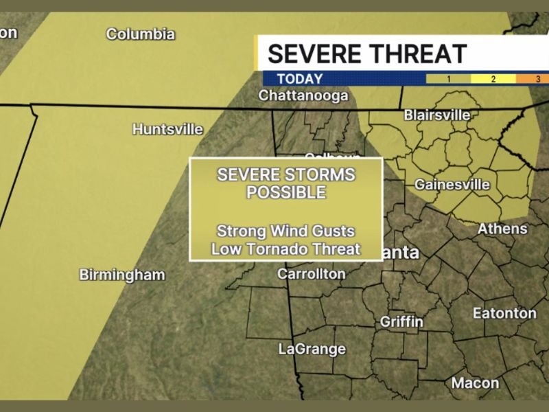
Damaging Wind Gusts and Low Tornado Threat Targeting North Georgia and NW Georgia Including Atlanta, Gainesville, and Chattanooga Area Through Friday Evening
NORTH AND NORTHWEST GEORGIA — Severe storms are possible across north and northwest Georgia later today and through the evening hours of Friday, May 22, 2026, with damaging wind gusts as the primary threat and a brief tornado possible mainly during the evening. The severe threat zone covers a broad corridor including Atlanta, Gainesville, Carrollton, and the Chattanooga border area, with the risk area since expanded to include all of northwest Georgia beyond the original forecast zone.
Damaging Wind Gusts Headline the Severe Threat Across North Georgia Friday Evening
Strong and damaging wind gusts are the main hazard associated with today’s severe storm potential across north Georgia. Storms developing through the afternoon and evening hours will carry the potential to produce wind gusts capable of downing trees and powerlines across the affected corridor.
The threat zone stretches from the Alabama border eastward through Carrollton, Atlanta, and Gainesville toward the Blairsville and Greenville zones. Residents across this entire corridor should secure any loose outdoor items and be prepared for rapidly changing conditions as storms develop through the late afternoon and evening hours.
Brief Tornado Possible Mainly During the Evening Hours Across the Risk Zone
Beyond the wind threat, a brief tornado cannot be ruled out across the severe risk zone mainly through the evening hours Friday. The tornado threat remains low in overall probability but real enough to warrant having a shelter plan identified well before evening arrives across north and northwest Georgia.
Communities including Athens, Griffin, and Eatonton fall within the broader yellow risk zone and should remain alert through the evening period. Given how quickly these events can develop, waiting for a warning before taking shelter is not a recommended approach on a day when tornado potential exists.
Expanded Risk Zone Now Covers All of Northwest Georgia Through Friday
The original severe threat area has since been expanded to include all of northwest Georgia, broadening the corridor of concern beyond what was initially outlined earlier Friday. This expansion means additional communities across the northwest corner of the state now fall within the active severe weather risk zone through the evening.
Huntsville and Birmingham to the west also sit within the outer edge of the broader risk area. Staying connected to local weather alerts and monitoring conditions through the evening is strongly advised for all residents across north and northwest Georgia on Friday. Stay with NapervilleLocal.com for the latest weather updates and local forecast coverage.

I’ve lived in Naperville long enough to see how quickly our community changes — from new developments downtown to sudden shifts in our Midwest weather. Reporting on Naperville news and daily forecasts gives me the chance to keep neighbors informed about what really matters. My goal is simple: deliver clear, timely updates so you always know what’s happening in our city and what to expect from the skies above.