
Scattered Showers Through Midday With Isolated Storms Shifting to Central and Western North Carolina Including Wilmington, Charlotte, and Knoxville Area Friday Afternoon
NORTH CAROLINA AND SURROUNDING REGION — Scattered showers are moving along the North Carolina coast Friday morning, expected to continue on and off through around lunchtime before drier conditions settle in for the afternoon and evening along the coast. Inland and into western North Carolina, only a few isolated showers are occurring this morning, with scattered showers and possibly isolated storms shifting focus toward central and western portions of the state through the afternoon and evening hours.
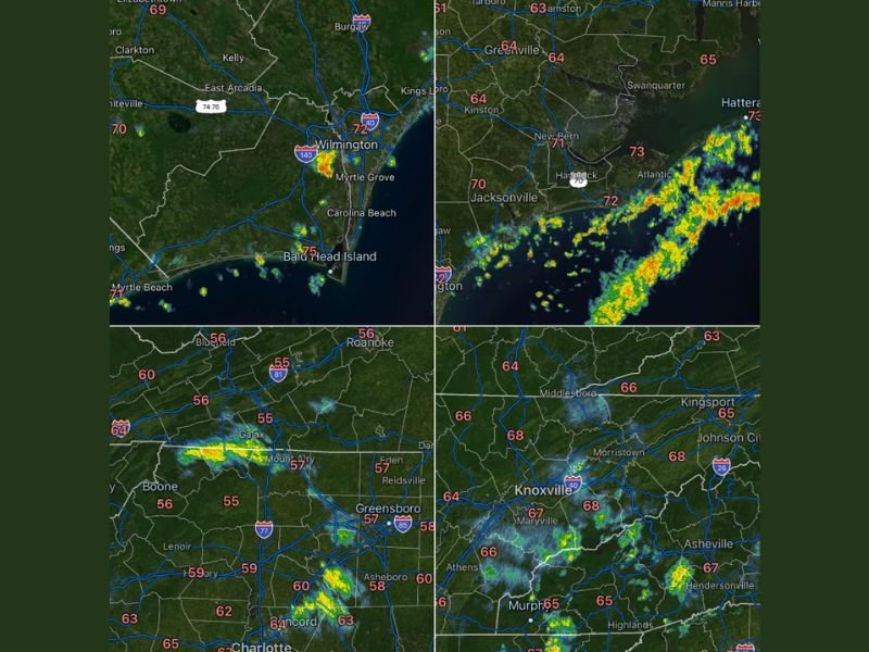
Coastal Showers From Wilmington Through the Outer Banks Active Through Midday
Radar imagery shows active shower coverage pushing along the North Carolina coastline Friday morning, with moderate to locally heavy signatures visible near Wilmington, Jacksonville, New Bern, and stretching toward Hatteras and the Outer Banks. Temperatures along the coast are ranging from the low to mid 70s, with Bald Head Island at 75 and Hatteras reaching 73 degrees.
Coastal shower activity will remain on and off through approximately lunchtime before drier and quieter weather takes hold for the afternoon and evening. Beachgoers and coastal residents should expect the most unsettled conditions of the day during the morning hours before conditions improve heading into the afternoon.
Isolated Showers Across Western NC With Storm Chances Building Inland This Afternoon
Inland and across western North Carolina, only a few isolated showers are occurring through the morning hours with radar showing scattered light to moderate signatures near the Boone, Galax, and Mount Airy zones. Temperatures across the western and piedmont regions are cooler, ranging from the mid to upper 50s near Boone, Roanoke, and Bluefield up through 63 to 64 degrees across the Greensboro and Charlotte areas.
The afternoon and evening will bring a shift in storm focus toward central and western North Carolina as daytime heating increases instability across the region. Scattered showers and possibly isolated storms developing during this window will be the main weather concern for inland communities through the evening hours.
Knoxville and East Tennessee Corridor Also Seeing Morning Shower Activity Friday
Radar across the eastern Tennessee and Knoxville corridor shows scattered shower and storm activity present Friday morning, with green to yellow signatures visible across the Knoxville, Maryville, Morristown, and Johnson City zones. Temperatures in this corridor are ranging from the mid 60s to near 68 degrees through the morning hours.
Residents across the Knoxville area and surrounding east Tennessee communities should remain aware of on and off shower activity through the day as the broader regional pattern keeps unsettled conditions in place. Staying connected to local forecasts through the afternoon will be important as storm chances evolve across both North Carolina and the adjacent Tennessee corridor. Stay with NapervilleLocal.com for the latest weather updates and local forecast coverage.

I’ve lived in Naperville long enough to see how quickly our community changes — from new developments downtown to sudden shifts in our Midwest weather. Reporting on Naperville news and daily forecasts gives me the chance to keep neighbors informed about what really matters. My goal is simple: deliver clear, timely updates so you always know what’s happening in our city and what to expect from the skies above.