
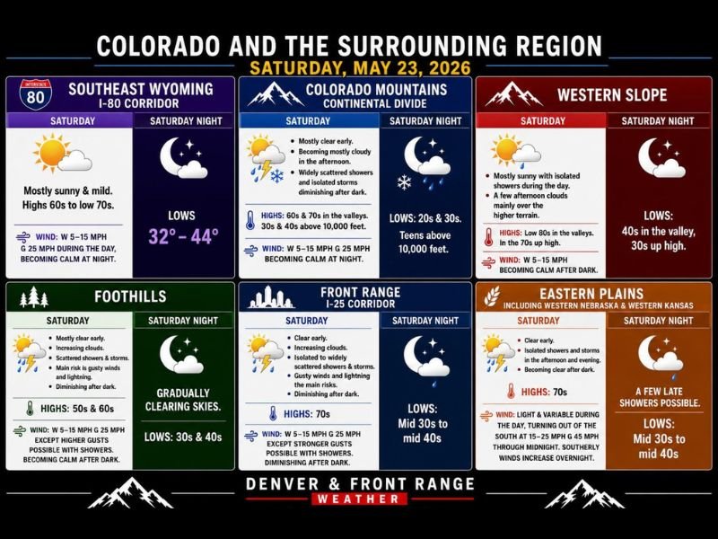
Widely Scattered Storms With Gusty Winds, Lightning, and Hail Threat Targeting Colorado, SW Nebraska, and Western Kansas Including the Front Range and Eastern Plains Saturday May 23
COLORADO AND SURROUNDING REGION — A warming trend is underway across Colorado and the surrounding region on Saturday, May 23, 2026, but enough moisture is present to spark widely scattered afternoon and evening storms across multiple zones. Gusty winds and lightning are the primary risks statewide, while the far eastern plains including far eastern Colorado, southwest Nebraska, and western Kansas face the highest threat with strong hail-producing storms possible through the evening.
Front Range and I-25 Corridor Facing Scattered Storms With Gusty Winds This Afternoon
The Front Range and I-25 corridor starts Saturday clear before increasing clouds bring isolated to widely scattered showers and storms through the afternoon. Highs reach the 70s with gusty winds and lightning as the main risks, diminishing after dark with overnight lows in the mid 30s to mid 40s.
The foothills carry a similar setup with scattered showers and storms through the afternoon, highs in the 50s and 60s, and gradually clearing skies overnight with lows in the 30s and 40s.
Far Eastern Plains Carry Highest Storm Risk With Hail-Capable Cells Possible Saturday
The far eastern plains hold the most significant storm threat Saturday, where better moisture and instability support strong storms capable of producing hail across far eastern Colorado, southwest Nebraska, and western Kansas. Eastern plains highs reach the 70s before southerly winds increase to 15 to 25 mph with gusts to 45 mph overnight.
A few late showers remain possible overnight before the plains clear with lows dropping to the mid 30s to mid 40s.
Mountain and Western Slope Zones See Afternoon Showers Before Clearing After Dark
The Colorado mountains will start mostly clear before afternoon clouds bring widely scattered showers and isolated storms, diminishing after dark. Valley highs reach the 60s and 70s while elevations above 10,000 feet stay in the 30s and 40s with teen overnight lows at the highest elevations.
The Western Slope stays mostly sunny with isolated showers over the higher terrain and valley highs reaching the low 80s. Memorial Day Monday will bring the hottest conditions of the week with 80s and low 90s east of the Continental Divide and scattered storm chances returning across the region. Stay with NapervilleLocal.com for the latest weather updates and local forecast coverage.

I’ve lived in Naperville long enough to see how quickly our community changes — from new developments downtown to sudden shifts in our Midwest weather. Reporting on Naperville news and daily forecasts gives me the chance to keep neighbors informed about what really matters. My goal is simple: deliver clear, timely updates so you always know what’s happening in our city and what to expect from the skies above.