
Gusty Winds, Large Hail, and Isolated Tornado Threat Across Colorado, Eastern Plains, and Wyoming on the Warmest Day of the Week Memorial Day Monday
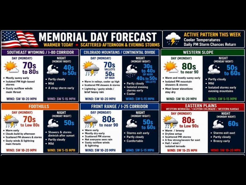
COLORADO AND SURROUNDING REGION — Memorial Day Monday, May 25, 2026, is shaping up as the warmest day of the week across Colorado and the surrounding region, but scattered afternoon and evening storms will develop with daytime heating moving generally north to south across multiple zones. The main risks statewide are gusty outflow winds and lightning, while the far eastern plains along a pseudo-dry line carry an elevated threat with a few strong to severe storms capable of all hazard modes including damaging winds, large hail, and an isolated tornado possible.
Eastern Plains Dryline Setup Carrying the Most Significant Severe Weather Risk Monday
The far eastern plains across western Nebraska, eastern Colorado, and western Kansas face the highest storm threat Monday as a pseudo-dry line sets up along the boundary. A few strong to severe storms are possible along this boundary with all severe weather modes on the table, though damaging winds and large hail are identified as the primary hazards.
Eastern plains highs will surge into the 80s to low 90s with warm and breezy conditions through the morning before dryline-driven storms develop through the afternoon. An isolated tornado cannot be ruled out for the far eastern zones, making this the most closely watched portion of the Monday forecast.
Front Range and I-25 Corridor Warm and Mostly Dry With Scattered Storms Developing
The Front Range and I-25 corridor will be warm early with highs reaching the 80s to near 90 degrees and mostly dry conditions through much of the morning. Scattered PM storms will develop through the afternoon, with not everyone seeing rain but gusty outflow winds and lightning posing the main risks for those under any cell that does develop.
Storm activity exits early into Monday night with temperatures dropping to the 50s to 60s under partly cloudy skies. Winds will be southwest at 10 to 20 mph through the day, becoming lighter at 5 to 15 mph overnight as conditions settle down across the corridor.
Mountains and Western Slope See Scattered PM Storms by Noon to 1PM Monday
The Colorado mountains and Continental Divide will see warm valley conditions with highs in the 70s before scattered PM showers and storms develop by noon to 1PM. Brief heavy rain, lightning, and gusty winds are the main concerns across the mountain zones, with higher elevations staying cooler in the 40s and 50s and overnight lows dropping to 30s and 40s.
The Western Slope will be warm and mostly sunny early with highs reaching the 80s to near 90 degrees before isolated PM mountain showers and storms develop through the afternoon. Most lower elevations on the Western Slope will stay dry through the day with storms primarily affecting the higher terrain.
Active Pattern Continues All Week With Daily PM Storm Chances and Cooler Temperatures Returning
After Monday’s warmest day of the week, temperatures will taper back into a mix of 70s and 80s through the remainder of the week as the active weather pattern continues. Daily afternoon and evening storm chances will remain a consistent fixture across Colorado and the surrounding region through the week and into the weekend.
Residents across all zones should check in daily for forecast updates as each day will bring its own storm timing and intensity details. Nowcast updates will be provided throughout the day as needed for any rapidly developing severe weather situations across the region. Stay with NapervilleLocal.com for the latest weather updates and local forecast coverage.

I’ve lived in Naperville long enough to see how quickly our community changes — from new developments downtown to sudden shifts in our Midwest weather. Reporting on Naperville news and daily forecasts gives me the chance to keep neighbors informed about what really matters. My goal is simple: deliver clear, timely updates so you always know what’s happening in our city and what to expect from the skies above.