
Jet Stream Dip Funneling Tropical Moisture Into the Gulf Coast and Southeast With Pattern Sliding East Through the Week and Small Atlantic Development Window Possible Next Week
GULF COAST AND SOUTHEAST UNITED STATES — A jet stream dip is actively funneling tropical moisture northward into the Gulf Coast and Southeast this week, keeping the region locked in a persistently wet and active weather pattern through the coming days. The pattern is expected to continue sliding eastward and flattening out heading into next week, with high atmospheric shear currently suppressing any meaningful tropical development despite the abundant moisture flow. A small window for limited Atlantic development may emerge next week as the system slides off to the northeast.
Jet Stream Dip Driving Continuous Tropical Moisture Flow Into the Gulf and Southeast
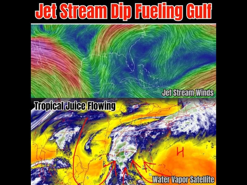
The jet stream wind analysis shows a pronounced dip in the flow pulling tropical moisture northward from the Gulf of Mexico and into the broader Southeast corridor. This atmospheric setup is the primary driver behind the ongoing heavy rainfall and active storm pattern that has been impacting the region through the week.
Water vapor satellite imagery confirms multiple streams of deep tropical moisture being directed northward into the Gulf Coast states, with the yellow and orange moisture signatures on the satellite clearly showing the rich tropical feed flowing onshore. This continuous moisture supply is keeping rain and storm chances elevated on a persistent daily basis across the affected corridor.
High Shear Environment Currently Suppressing Tropical Development Despite Rich Moisture
Despite the abundant tropical moisture being pulled into the region, significant atmospheric shear is present across the area and is effectively suppressing any organized tropical development at this time. Forecasters note that tropical development is not likely under the current high shear environment that accompanies the active jet stream pattern.
The combination of rich moisture without organized tropical development means the primary impact of this setup remains heavy rainfall and severe storm potential rather than any named tropical system threat. Residents across the Gulf Coast and Southeast should focus on the ongoing flooding and storm risks rather than any tropical system concerns through the current week.
Pattern Slides East and Flattens Next Week With Small Atlantic Development Window Possible
The active jet stream dip pattern is expected to slide eastward through the week before beginning to flatten out heading into next week. This gradual shift will eventually reduce the direct tropical moisture feed into the Gulf Coast states, though the wet and unsettled pattern will persist through the transition period.
As the system slides off to the northeast next week, a small window for limited Atlantic development may open briefly before the pattern fully flattens. Forecasters are monitoring this potential development window but emphasize the overall probability remains low given the evolving atmospheric conditions heading into the following week. Stay with NapervilleLocal.com for the latest weather updates and local forecast coverage.

I’ve lived in Naperville long enough to see how quickly our community changes — from new developments downtown to sudden shifts in our Midwest weather. Reporting on Naperville news and daily forecasts gives me the chance to keep neighbors informed about what really matters. My goal is simple: deliver clear, timely updates so you always know what’s happening in our city and what to expect from the skies above.