
Hit or Miss Heavy Downpours and Lightning Active Across the Carolinas and Tennessee Including Rockingham, Greenville, Goldsboro, and Knoxville With Feast or Famine Rainfall Pattern Monday
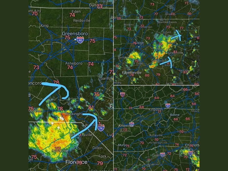
CAROLINAS AND TENNESSEE — Scattered hit or miss showers and thunderstorms are moving through the Carolinas and Tennessee on Monday, May 25, 2026, bringing bursts of heavy rainfall and lightning to some communities while leaving others completely dry in a classic summertime feast or famine pattern. Radar at 10:33AM shows active storm cores with lightning strikes near Rockingham and Bennettsville in the south, moderate returns near Goldsboro and Greenville in the east, and scattered light activity across the western mountain zones near Asheville and Knoxville.
Active Storm Cores With Lightning Firing Near Rockingham and Bennettsville Monday Morning
The most intense radar returns visible at 10:33AM are concentrated near Rockingham, Bennettsville, and Laurinburg in the south-central Carolina zone, where yellow and orange signatures with active lightning strikes indicate the heaviest and most organized storm activity currently impacting the region. Temperatures in this zone range from 77 to 81 degrees, providing ample surface heating to sustain ongoing storm development.
The hit or miss nature of these storms means communities just a few miles from the heaviest cores may be seeing no rain at all while others are experiencing significant downpours. This highly localized rainfall distribution is characteristic of the summertime storm pattern currently in place across the Carolinas.
Eastern Carolina Corridor Seeing Moderate Storm Activity From Wilson Through Goldsboro
The eastern North Carolina corridor is also experiencing moderate storm activity Monday morning, with green and yellow radar returns visible from Wilson and Tarboro southward through Goldsboro and Kinston. Temperatures across this eastern zone are running from the upper 70s to low 80s, with Greenville at 81 and Goldsboro also reaching 81 degrees through the morning hours.
The storm coverage across eastern North Carolina is more scattered and less intense than the Rockingham corridor to the south, but locally heavy bursts of rainfall and lightning remain possible across any community that falls under an active cell through the day. The feast or famine pattern means rainfall totals will be extremely uneven across the region.
Western Mountain Zones From Asheville Through Knoxville Seeing Mostly Quiet Conditions
Western portions of the Carolinas and Tennessee including Asheville, Knoxville, Boone, and Hendersonville are seeing much quieter conditions Monday morning with little to no radar returns across the mountain zones. Temperatures across the western corridor are cooler, ranging from the mid 60s to low 70s, with Knoxville at 73 and Asheville reaching 70 degrees.
The hit or miss storm pattern is expected to continue on and off throughout the day across the entire state as summertime heating drives storm development in unpredictable and localized patterns. Residents across all zones should stay connected to local radar and be prepared for conditions to change quickly if a heavy cell develops nearby. Stay with NapervilleLocal.com for the latest weather updates and local forecast coverage.

I’ve lived in Naperville long enough to see how quickly our community changes — from new developments downtown to sudden shifts in our Midwest weather. Reporting on Naperville news and daily forecasts gives me the chance to keep neighbors informed about what really matters. My goal is simple: deliver clear, timely updates so you always know what’s happening in our city and what to expect from the skies above.