
Gusty Winds, Large Hail, and Blowing Dust Targeting Colorado, Wyoming, and Eastern Plains Including Denver, Pueblo, and Western Nebraska With Gusts to 55 MPH Tuesday
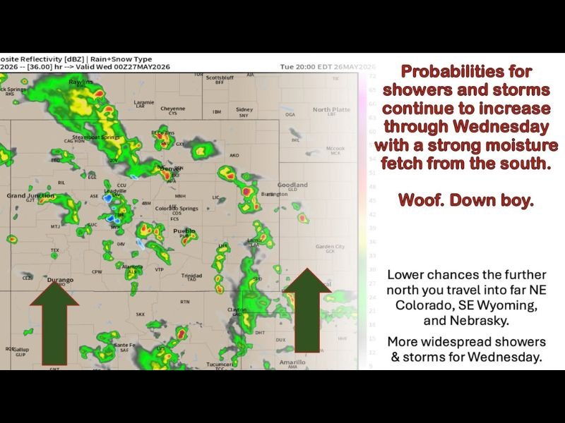
COLORADO AND SURROUNDING REGION — An active and breezy weather pattern continues across Colorado and the surrounding region on Tuesday, May 26, 2026, as shortwave disturbances embedded in a strong southerly flow keep scattered showers and thunderstorms firing across multiple zones through the day and into the evening. Strong southerly winds with gusts reaching 35 to 55 mph across the eastern plains and Front Range corridor make this a multi-hazard day, while storm probabilities are forecast to continue increasing through Wednesday as a stronger moisture fetch builds from the south.
Front Range and I-25 Corridor Facing Scattered Storms Mainly 2PM to 9PM Tuesday
The Front Range and I-25 corridor will be warm and breezy Tuesday with highs reaching 77 to 85 degrees and southeast winds of 15 to 25 mph with gusts to 30 to 40 mph. Scattered showers and storms will develop mainly between 2PM and 9PM, moving generally from south to north through the afternoon and evening hours.
Stronger storms across the Front Range corridor are capable of producing gusty outflow winds and small hail through the afternoon storm window. Morning hours will be the best window for any outdoor activities before storm development ramps up after 2PM across the Denver metro and surrounding communities.
Eastern Plains Facing the Most Dangerous Conditions With Gusts to 55 MPH and Blowing Dust
The eastern plains including northeast Colorado, northwest Kansas, and western Nebraska carry the most hazardous conditions Tuesday, with sustained winds of 20 to 30 mph and gusts reaching 35 to 55 mph creating dangerous travel conditions and the potential for blowing dust across open terrain. Highs will surge into the 82 to 92 degree range making this the hottest zone in the region.
Scattered storms will impact 20 to 40 percent of the eastern plains corridor through the day, with gusty outflow winds adding to the already dangerous wind conditions across the zone. Any storm that develops in this environment will be capable of producing significant wind damage given the extreme background wind speeds already in place.
Foothills, Mountains, and Western Slope Seeing Heavy Rain and Small Hail With Scattered Storms
The foothills, mountains, and western slope are all seeing scattered showers and storms Tuesday with heavy rain and small hail possible across the terrain zones. Mountain highs will reach 55 to 70 degrees while the western slope surges into the 80 to 92 degree range with southeast winds of 10 to 20 mph and gusts to 25 to 35 mph.
Gusty outflow winds from stronger mountain storms will be a concern through the afternoon hours across the foothills corridor. Storm activity across the mountains and western slope will be most numerous early in the day before shifting focus toward the Front Range and eastern plains through the afternoon and evening.
Storm Probabilities Increasing Through Wednesday With Active Pattern Continuing Into the Weekend
Storm probabilities will continue increasing through Wednesday as a stronger moisture fetch from the south builds into the region, with Wednesday’s disturbance focusing activity along and east of the Continental Divide including the foothills, Front Range, I-25 corridor, eastern plains, southeast Wyoming, and western Nebraska Panhandle. A brief relative lull is possible Thursday before the pattern ramps back up heading into the weekend and next week.
No widespread severe weather outbreak is forecast this week but stronger storms remain capable of producing gusty and potentially damaging winds, microbursts, and large hail on any given afternoon. Morning hours are the safest window for outdoor activities each day as afternoon heating drives the daily storm development cycle across the region.
Stay with NapervilleLocal.com for the latest weather updates and local forecast coverage.

I’ve lived in Naperville long enough to see how quickly our community changes — from new developments downtown to sudden shifts in our Midwest weather. Reporting on Naperville news and daily forecasts gives me the chance to keep neighbors informed about what really matters. My goal is simple: deliver clear, timely updates so you always know what’s happening in our city and what to expect from the skies above.