
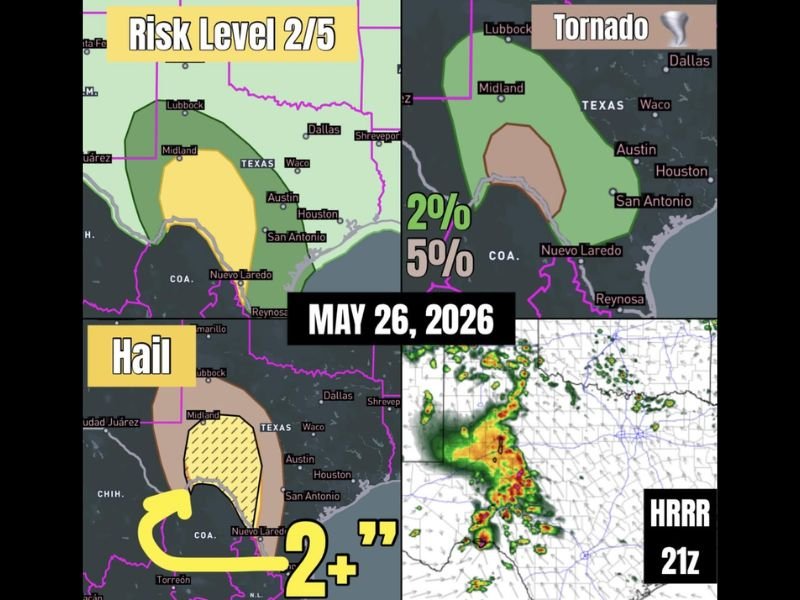
Risk Level 2 Severe Weather With Very Large Hail Over 2 Inches and Tail End Tornado Potential Targeting Southwest Texas Including Midland, San Antonio, and Laredo Tuesday May 26
SOUTHWEST TEXAS — Southwest Texas is the focal point for today’s severe weather setup on Tuesday, May 26, 2026, as ongoing storms encounter increasing moisture and instability across the region, producing a Risk Level 2 out of 5 severe weather threat. Very large hail of 2 inches or greater is the primary hazard mode, but a tail end Charlie supercell carrying real tornado potential could develop before the storm system lines out, making this a notably dangerous setup for late May across the southern Texas corridor.
Risk Level 2 Setup With Very Large Hail as the Primary Hazard Across Southwest Texas
The Risk Level 2 designation covers a broad zone across southwest Texas from near Lubbock and Midland southward through San Antonio and toward the Nuevo Laredo corridor, with a Level 1 buffer zone extending the overall risk footprint across a wider area. Very large hail of 2 inches or greater is identified as the dominant severe weather mode as storms encounter increasing moisture and instability through the day.
The hatched hail risk zone on the forecast map specifically highlights the area of greatest concern for 2-plus inch hail, centered across the Midland through San Antonio corridor and extending southward. Residents across this zone should protect vehicles and any hail-sensitive property immediately as storm development is already underway this morning.
Tail End Charlie Supercell Could Produce Tornado Before Storm System Lines Out
Beyond the significant hail threat, forecasters are watching closely for a tail end Charlie supercell to develop along the southern end of the storm line before the system transitions to a more linear mode. This trailing supercell would have real tornado potential, with the tornado probability sitting at 2 percent broadly and 5 percent within the more focused inner risk zone centered south of San Antonio toward Nuevo Laredo.
The tail end Charlie scenario is a well-known supercell setup where the southernmost storm on a line benefits from the best atmospheric inflow and least interference from other cells. While the overall tornado probability is not high, any tornado that does develop from this type of setup can be significant and form with limited warning time.
HRRR Model Showing Active Storm Development Already Underway Across the Corridor
The HRRR 21z model simulation depicts active and organized storm development already underway across the southwest Texas corridor, with intense yellow and red radar cores shown in the model output. The storm cluster depicted on the HRRR is compact but intense, consistent with the supercell mode described in today’s severe weather setup.
Forecasters note this is a notably far south severe weather setup for late May, adding an element of unusual atmospheric interest to today’s storm threat. All residents across the Risk Level 2 zone from Midland through San Antonio and southward should treat this threat seriously and have a shelter plan in place before any storm activity reaches their community today. Stay with NapervilleLocal.com for the latest weather updates and local forecast coverage.

I’ve lived in Naperville long enough to see how quickly our community changes — from new developments downtown to sudden shifts in our Midwest weather. Reporting on Naperville news and daily forecasts gives me the chance to keep neighbors informed about what really matters. My goal is simple: deliver clear, timely updates so you always know what’s happening in our city and what to expect from the skies above.