
Heavy Rain Threat Across Two Separate Zones Targeting the Gulf Coast, Southeast, and South Texas With Slight to Marginal Risk Areas Active From the Carolinas Through Texas
GULF COAST AND SOUTHEASTERN UNITED STATES — Heavy rain is the headline threat across two distinct risk zones on Tuesday, May 26, 2026, with Slight and Marginal heavy rain designations covering a broad swath from South Texas westward and separately from the Gulf Coast through the Carolinas and Mid-Atlantic coastline. The persistent and relentless wet pattern continues to hammer the Gulf Coast region with more rain expected all week as the active summer moisture pattern shows no meaningful signs of breaking.
Two Separate Heavy Rain Risk Zones Active Simultaneously Across the Country Tuesday
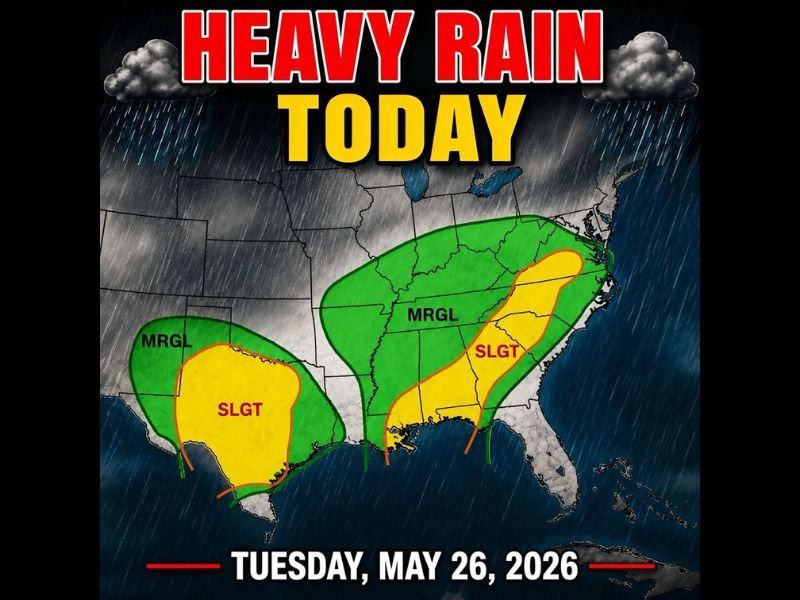
The heavy rain map for Tuesday shows two clearly defined risk corridors active at the same time. The western zone covers South Texas and extends into Mexico with a Slight risk core surrounded by a Marginal risk buffer, while the eastern zone stretches from the Gulf Coast through the Deep South and up through the Carolinas with a Slight risk corridor along the immediate coastline.
The dual-zone setup reflects the broad geographic reach of today’s heavy rain threat, meaning millions of residents across two very different parts of the country are simultaneously dealing with flood-producing rainfall potential through the day.
Gulf Coast Slight Risk Zone Signals Flood Producing Rain Rates Along the Coastal Corridor
The Slight heavy rain designation along the Gulf Coast and Carolina coastline represents the highest risk tier on today’s map and signals the greatest potential for flood-producing rainfall rates across the immediate coastal communities. Areas within this yellow zone face the most concentrated risk for localized flash flooding wherever training storms develop through the day.
The Marginal risk zone surrounding the Slight area extends the broader heavy rain concern inland across the Deep South and up through the Mid-Atlantic, keeping a wide swath of communities on alert for at least isolated heavy downpours through Tuesday.
More Rain Expected All Week as Gulf Coast Summer Moisture Pattern Continues
Beyond Tuesday, the active and relentless Gulf Coast moisture pattern is forecast to continue delivering daily heavy rain chances throughout the week. Residents across the Gulf Coast and Southeast should plan for an extended period of wet conditions with no meaningful dry pattern break on the immediate horizon. Stay with NapervilleLocal.com for the latest weather updates and local forecast coverage.

I’ve lived in Naperville long enough to see how quickly our community changes — from new developments downtown to sudden shifts in our Midwest weather. Reporting on Naperville news and daily forecasts gives me the chance to keep neighbors informed about what really matters. My goal is simple: deliver clear, timely updates so you always know what’s happening in our city and what to expect from the skies above.