
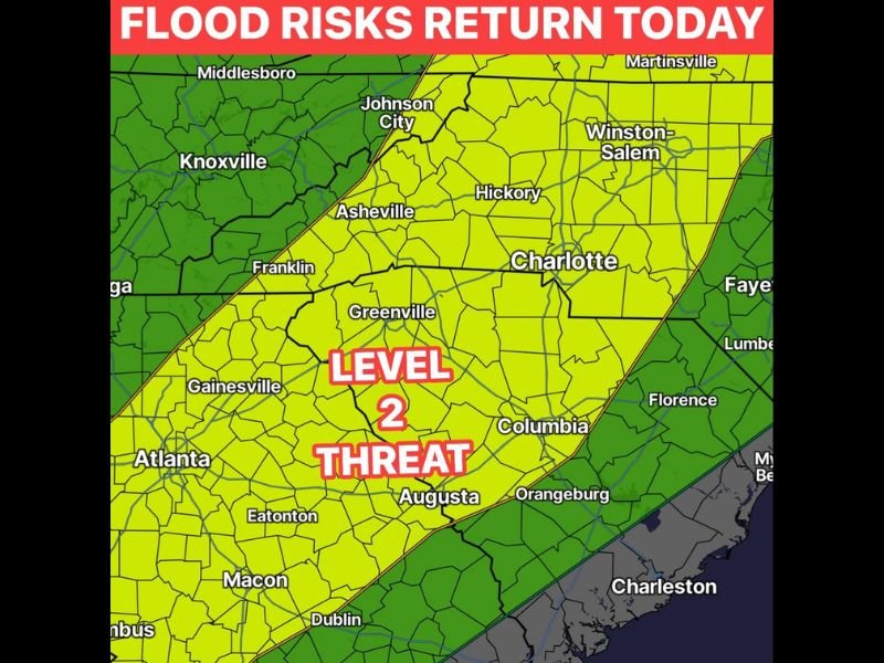
Level 2 Flood Threat Returning Across the Carolinas and North Georgia Including Charlotte, Greenville, Asheville, and Columbia With Several Inches Possible Again Today
CAROLINAS AND NORTH GEORGIA — A Level 2 flood threat is returning this afternoon and evening across a broad corridor covering the Carolinas and north Georgia, with several inches of rain capable of falling in only a few hours on top of already completely saturated ground. Henderson County recorded over 6 inches of rain in roughly three hours overnight, and with soil moisture fully maxed out, any additional rainfall today will run off dramatically faster with even modest rain posing an immediate flood risk across the most impacted areas.
Level 2 Flood Zone Stretches From Asheville and Greenville Through Charlotte and Columbia
The Level 2 flood threat covers a wide corridor from Asheville and Greenville through Charlotte, Hickory, and Winston-Salem southward through Columbia, Augusta, and Orangeburg. A broader Level 1 zone extends the concern further outward to include Johnson City, Franklin, Gainesville, Atlanta, Macon, and Dublin.
This elevated threat reflects the dangerous combination of saturated ground from prior events and another potentially heavy rainfall round arriving this afternoon. The entire western and central Carolina corridor needs to treat today as a serious flood weather day.
Henderson County 6 Plus Inches Overnight Means Any Rain Today Is Too Much
Over 6 inches fell across parts of Henderson County in approximately three hours overnight, leaving ground conditions completely beyond saturation capacity across the region. Forecasters are explicitly warning that any additional rainfall today will be too much for the most impacted spots.
This overnight accumulation has eliminated any remaining capacity in the soil and drainage infrastructure to absorb new rainfall. Flash flooding can develop almost instantaneously when heavy rain arrives on ground already in this condition.
Several Inches Possible Again This Afternoon on Fully Saturated Ground
Just like the prior day, several inches of rain could fall in only a few hours across the Level 2 zone this afternoon and evening. The repeat heavy rainfall scenario on fully saturated ground is one of the most dangerous flash flood setups possible, with runoff rates dramatically accelerated compared to normal conditions.
Residents across all communities within the Level 2 zone should avoid any travel during heavy rain and stay closely connected to local flood warnings through the evening hours. Stay with NapervilleLocal.com for the latest weather updates and local forecast coverage.

I’ve lived in Naperville long enough to see how quickly our community changes — from new developments downtown to sudden shifts in our Midwest weather. Reporting on Naperville news and daily forecasts gives me the chance to keep neighbors informed about what really matters. My goal is simple: deliver clear, timely updates so you always know what’s happening in our city and what to expect from the skies above.