
Heavy Rainfall Returning to Houston and South Texas Including Corpus Christi, Lake Jackson, and Victoria During Wednesday Morning Commute After 168-Hour Totals
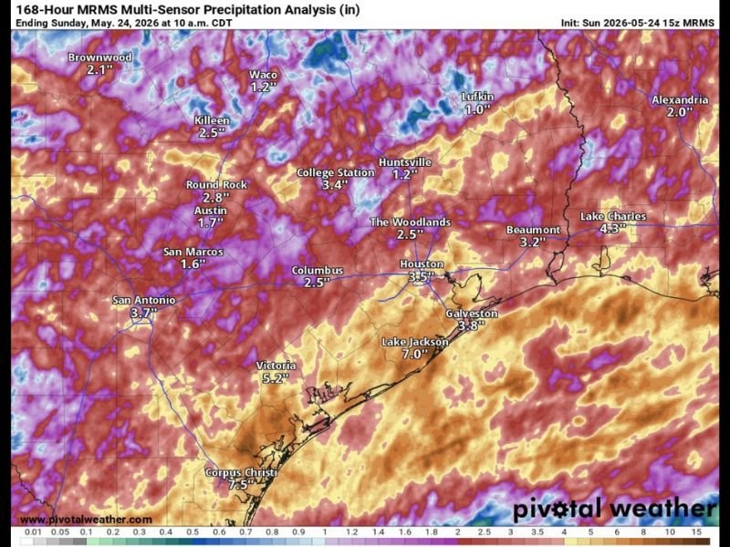
HOUSTON AND SOUTH TEXAS — Potentially heavy rainfall is returning to the Houston area and broader South Texas region on Wednesday, May 26, 2026, with storms possibly hitting during the morning commute hours following a brief Memorial Day break. The 168-hour MRMS multi-sensor precipitation analysis ending Sunday May 24 at 10AM CDT shows the region has already absorbed significant weekly rainfall, with Corpus Christi leading at 7.5 inches, Lake Jackson at 7.0 inches, and Victoria at 5.2 inches across the prior week. The weekend is forecast to turn warmer and mostly rain-free after Wednesday’s event clears.
168-Hour Analysis Shows Widespread 3 to 7 Inch Totals Already Recorded Across the Region
The week-long precipitation analysis shows widespread red and orange signatures blanketing the entire Houston metro and South Texas corridor, reflecting significant accumulated rainfall from the prior seven days. Houston recorded 3.5 inches through the analysis period while The Woodlands sits at 2.5 inches, Galveston at 3.8 inches, and Lake Charles at 4.3 inches across the broader corridor.
The heaviest totals are concentrated along the southern coastal zones, with Corpus Christi at 7.5 inches, Lake Jackson at 7.0 inches, and Victoria at 5.2 inches leading the regional accumulation totals. These existing totals mean the ground across much of the region is carrying significant moisture load ahead of Wednesday’s incoming rainfall event.
Wednesday Morning Commute at Risk as Heavy Storms Potentially Impact the Houston Region
The timing of Wednesday’s returning heavy rainfall is particularly concerning as storms may develop and impact the Houston region during the morning commute hours. Commuters across Houston and surrounding communities should monitor conditions closely before heading out Wednesday morning and allow extra travel time if heavy rain is actively falling.
Morning commute storm impacts can create rapidly developing street flooding, reduced visibility, and hazardous road conditions across the Houston metro. The combination of already-saturated ground from the prior week’s rainfall and new heavy rain arriving during peak traffic hours creates a compounding risk for drivers across the region Wednesday morning.
Weekend Turns Warmer and Mostly Rain-Free After Wednesday Event Clears Houston
After Wednesday’s heavy rainfall event moves through, the Houston area is forecast to transition into a warmer and mostly rain-free pattern heading into the weekend. This represents a welcome break from the persistent and active rainfall pattern that has been impacting the region throughout the prior week and into the Memorial Day holiday period.
Residents across Houston, Corpus Christi, Lake Jackson, Victoria, and surrounding South Texas communities should get through Wednesday’s storm threat before making any weekend outdoor plans with confidence. Once the Wednesday event clears, drier and warmer conditions are expected to settle in and provide a meaningful break from the prolonged wet pattern.
Stay with NapervilleLocal.com for the latest weather updates and local forecast coverage.

I’ve lived in Naperville long enough to see how quickly our community changes — from new developments downtown to sudden shifts in our Midwest weather. Reporting on Naperville news and daily forecasts gives me the chance to keep neighbors informed about what really matters. My goal is simple: deliver clear, timely updates so you always know what’s happening in our city and what to expect from the skies above.