
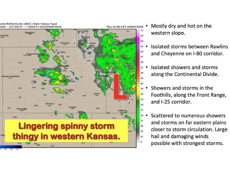
Scattered to Severe Storms With Damaging Winds and Large Hail Targeting Eastern Plains, Front Range, and Southeast Wyoming Including Denver, Cheyenne, and Western Kansas Thursday
COLORADO AND SURROUNDING REGION — An active Thursday, May 28, 2026, is ahead across Colorado and the surrounding region as scattered showers and thunderstorms develop from the foothills and Front Range through southeast Wyoming and into the far eastern plains, with a few isolated stronger to severe storms possible across the eastern plains where damaging winds and large hail are the primary concerns.
The western slope will be the hottest and driest zone with valley highs pushing 80 to near 90 degrees while storm activity focuses along and east of the Continental Divide through the afternoon and evening.
Eastern Plains Carrying the Most Significant Storm Threat With Damaging Winds and Large Hail
The far eastern plains including western Nebraska and western Kansas sit closest to the storm circulation and will see the most widespread and potentially severe storm activity Thursday afternoon and evening. Highs will reach the low to mid 80s with southeast winds of 15 to 25 mph and gusts to 45 mph, strengthening further with any storm that develops.
Damaging winds and large hail are both possible with the strongest storms across this zone, with a lingering storm circulation visible on radar near western Kansas keeping the threat elevated through the evening and into overnight hours. Storms are expected to linger across the eastern plains through Thursday night.
Front Range and Foothills See Afternoon Storms Mainly East of I-25 Through the Evening
The Front Range and I-25 corridor will be sunny and warm early with highs in the mid to upper 70s before a few afternoon storms develop mainly east of I-25 through the afternoon. Gusty winds with any storm are the primary concern along the corridor, with east to northeast winds of 5 to 10 mph becoming gusty with storm activity.
The foothills will see isolated afternoon storms with highs in the 70s and clearing skies developing overnight with lows dropping to the 40s and 50s.
Active Pattern Continues Friday Through the Weekend With Strong to Severe Storm Potential
Friday brings another round of scattered storms under southwest diffluent flow, with the northern Front Range including Denver, Fort Collins, Cheyenne, and the I-76 corridor into western Nebraska watching closely for strong to severe storm potential. The active pattern continues through the weekend with daily storm chances persisting into the first week of June. Stay with NapervilleLocal.com for the latest weather updates and local forecast coverage.

I’ve lived in Naperville long enough to see how quickly our community changes — from new developments downtown to sudden shifts in our Midwest weather. Reporting on Naperville news and daily forecasts gives me the chance to keep neighbors informed about what really matters. My goal is simple: deliver clear, timely updates so you always know what’s happening in our city and what to expect from the skies above.