
Omega Block Pattern Locking In Dry and Sunny 7 to 10 Day Outlook With Only a 20 Percent Isolated Shower Chance Today Before the Ridge Takes Full Control Through Late May
UNITED STATES — An Omega Block atmospheric pattern is establishing itself as the dominant weather feature across the country, bringing a dry and sunny 7 to 10 day outlook to much of the nation as a strong ridge of high pressure locks in and prevents weather systems from moving freely across the country.
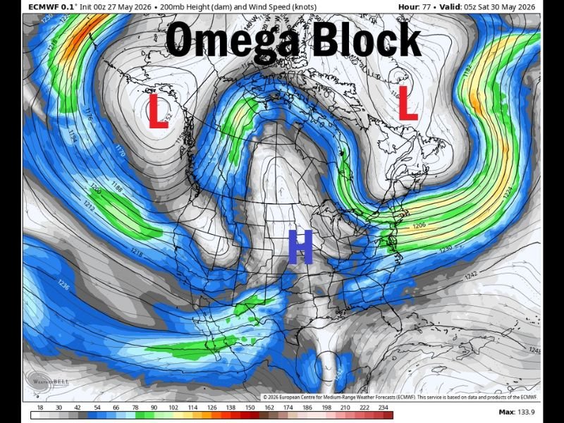
The ECMWF 200mb analysis valid at 05z Saturday May 30, 2026, clearly depicts the classic Omega Block structure with a dominant high pressure ridge flanked by low pressure troughs on both the West Coast and the East Coast, creating the Greek letter omega shape that gives this pattern its name.
Omega Block Structure Clearly Visible on ECMWF With Ridge Blocking Weather System Movement
The ECMWF 200mb height analysis initialized 00z May 27 shows the textbook Omega Block configuration, with a strong high pressure dome centered over the central portion of the country flanked by low pressure troughs sitting over the West Coast and the eastern Atlantic. This blocking configuration effectively prevents weather systems from tracking across the country in the normal west to east pattern.
When the ridge sits in the middle of this omega-shaped jet stream pattern, it acts as a wall that redirects storm systems around the edges rather than allowing them to push through the central portion of the country. The result is a prolonged period of dry, stable, and sunny conditions for areas sitting beneath the ridge.
Dry and Full Sunshine Expected for the Next 7 to 10 Days Under the Blocking Ridge
With the Omega Block now in place as the dominant atmospheric pattern, the 7 to 10 day outlook is dry and full of sunshine for the areas sitting beneath the central ridge. The blocking pattern is expected to be long-lasting, keeping unsettled weather locked out of the region for an extended period.
Only a 20 percent chance of an isolated shower exists today before the ridge fully consolidates its grip on the pattern. After today that slim shower chance diminishes as the blocking pattern takes complete control.
Edges of the Omega Block Bring Clouds and Rain While the Central Ridge Stays Dry
Communities sitting near the edges of the Omega Block where the low pressure troughs are positioned will continue to see clouds and rain near the blocking pattern boundaries. The central ridge beneath the high pressure core will enjoy the extended dry and sunny stretch while the pattern edges remain active. Stay with NapervilleLocal.com for the latest weather updates and local forecast coverage.

I’ve lived in Naperville long enough to see how quickly our community changes — from new developments downtown to sudden shifts in our Midwest weather. Reporting on Naperville news and daily forecasts gives me the chance to keep neighbors informed about what really matters. My goal is simple: deliver clear, timely updates so you always know what’s happening in our city and what to expect from the skies above.