
Multiple Models Hinting at Gulf System Development Between June 3 and 7 With Texas Through Florida Gulf Coast Advised to Monitor as Confidence Remains Very Low
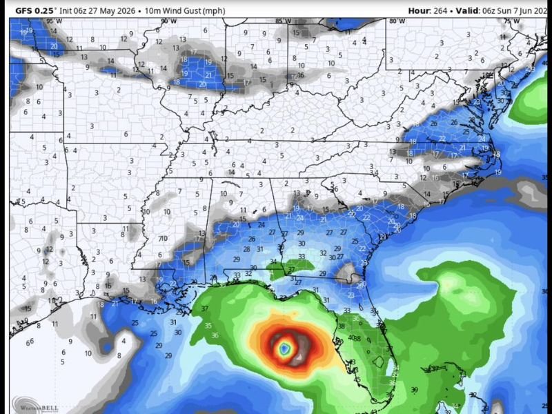
GULF COAST — Multiple long-range forecast models are producing signals of a potential Gulf of Mexico weather system development during the June 3 through 7, 2026 window, with the GFS model valid at 06z Sunday June 7 depicting a notable wind gust signature in the central Gulf with values reaching into the red and orange range indicating a potentially organized system. However, forecasters are urging the public to exercise significant caution before drawing any conclusions, as model runs are showing wildly different solutions from one run to the next with very low confidence at this extended range.
GFS Model Depicting Organized Wind Gust Signature in Central Gulf Valid June 7
The GFS 0.25 degree model initialized 06z May 27 and valid at 06z June 7 shows a concentrated and organized wind gust signature in the central Gulf of Mexico, with values at the core reaching into the orange and red range surrounded by a broad green circulation envelope. Wind gusts depicted along the Gulf Coast from Louisiana through Florida reach 27 to 38 mph in association with this modeled system.
This GFS depiction is one of several model solutions showing some form of Gulf disturbance during the June 3 to 7 window, though each model is placing the system in a different location and with dramatically different intensity solutions from run to run.
Extreme Model Uncertainty Means No Conclusions Should Be Drawn at This Range
Forecasters are emphatic that the current model spread on this potential Gulf system is enormous and that no reliable conclusions about track, intensity, or impacts can be drawn at this time. Solutions range from a Gulf low to a Florida timeout scenario to a Louisiana-focused system depending on which model run is examined, reflecting the classic high uncertainty of long-range tropical and near-tropical forecasting.
The consistency of multiple models producing some form of Gulf signal is worth noting, but that signal alone does not justify alarm or preparation beyond normal weather awareness at this stage.
Gulf Coast Residents From Texas Through Florida Should Monitor Casually Not Panic
Residents across the Gulf Coast from Texas through Florida are advised to keep a casual eye on forecast updates over the coming two weeks rather than reacting to individual model runs. Staying weather aware and following official NWS guidance as the June 3 to 7 window approaches is the appropriate and measured response to the current low-confidence signals. Stay with NapervilleLocal.com for the latest weather updates and local forecast coverage.

I’ve lived in Naperville long enough to see how quickly our community changes — from new developments downtown to sudden shifts in our Midwest weather. Reporting on Naperville news and daily forecasts gives me the chance to keep neighbors informed about what really matters. My goal is simple: deliver clear, timely updates so you always know what’s happening in our city and what to expect from the skies above.