
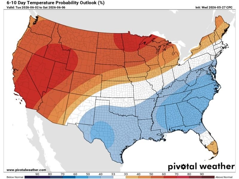
Above Normal Temperatures Sliding Into the West and Central US While Below Normal Temperatures Cover Texas and the Southeast Including Houston During the June 2 to 6 Period
UNITED STATES — A sharp temperature contrast is forecast across the country during the June 2 through 6, 2026 period, with the CPC 6 to 10 day temperature probability outlook showing above normal temperatures dominating the West, Plains, and Upper Midwest while below normal temperatures cover Texas, the Gulf Coast, and the broader Southeast.
Houston and the surrounding region are expected to slide into early summer conditions rather than jumping directly into extreme heat, a welcome development that forecasters are describing as an extended early summer period before more intense heat arrives later in the season.
Strong Above Normal Signal Covering the West Coast Through the Central Plains and Upper Midwest
The 6 to 10 day temperature outlook valid June 2 through June 6 shows deep red and dark orange above normal probability signatures covering virtually the entire western United States from California through Nevada, Utah, and into the central Plains. The strongest above normal signal, depicted in dark red, is centered across portions of the northern Plains and Upper Midwest including Nebraska, Iowa, and into the Great Lakes region.
This broad above normal temperature footprint indicates a high probability that temperatures will run significantly warmer than average across the western two-thirds of the country during this period. The western slope and desert Southwest are among the zones with the highest probability of above normal temperatures heading into early June.
Below Normal Temperatures Covering Texas, Gulf Coast, and Southeast Through June 2 to 6
In sharp contrast to the warm western pattern, below normal temperatures are forecast across Texas, Louisiana, the Gulf Coast, and the broader Southeast corridor during the June 2 through 6 window. The blue signature on the outlook map covers a wide swath from Texas through the Deep South and into the Carolinas and Florida, indicating a meaningful probability of cooler than average conditions across this zone.
For Houston specifically, this below normal signal supports the forecast for an extended early summer period with more comfortable temperatures rather than an immediate plunge into oppressive summer heat.
Houston Region Expected to Enjoy Extended Early Summer Period Before Intense Heat Arrives
The below normal temperature signal across the Houston region through early June is being welcomed as a buffer period before the inevitable arrival of true summer heat later in the season. Residents across Houston and the broader Gulf Coast can take the win of a cooler than normal early June before the heat of summer fully establishes itself across the region.
Stay with NapervilleLocal.com for the latest weather updates and local forecast coverage.

I’ve lived in Naperville long enough to see how quickly our community changes — from new developments downtown to sudden shifts in our Midwest weather. Reporting on Naperville news and daily forecasts gives me the chance to keep neighbors informed about what really matters. My goal is simple: deliver clear, timely updates so you always know what’s happening in our city and what to expect from the skies above.