
Severe Weather Including Supercells and Tornado Threat Targeting Nebraska Panhandle and Southwestern South Dakota Including Alliance, Sidney, and Rapid City Saturday
NEBRASKA PANHANDLE AND SOUTHWESTERN SOUTH DAKOTA — A significant severe weather setup is on the horizon for Saturday, May 30, 2026, as a belt of stronger atmospheric flow moves off the higher terrain and encounters increasing moisture across the Nebraska Panhandle and southwestern South Dakota.
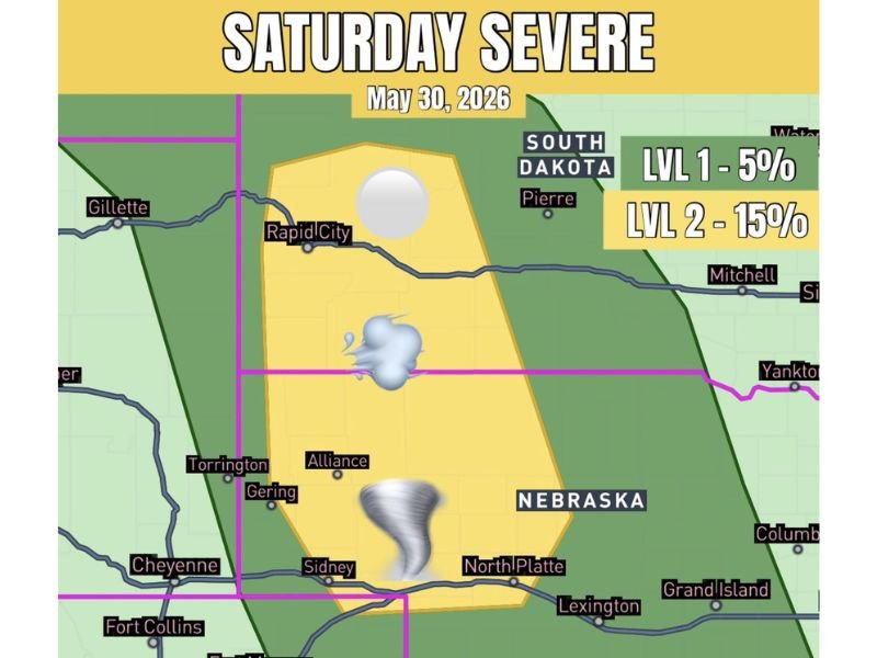
The severe risk carries a Level 2 designation at 15 percent covering the primary threat zone with a Level 1 at 5 percent surrounding it, with supercells capable of all severe weather modes including tornado, large hail, and damaging winds expected to develop across the corridor.
Level 2 Severe Risk With All Hazard Modes Active Across the Nebraska Panhandle Saturday
The Level 2 risk zone covers a broad corridor from the Nebraska Panhandle northward through southwestern South Dakota, encompassing communities including Alliance, Sidney, Gering, Torrington, and extending toward Rapid City. All modes of severe weather are on the table within this zone, making it one of the more significant Saturday setups of the late May period.
The combination of stronger flow off the higher terrain colliding with increasing low-level moisture creates the atmospheric recipe needed for organized supercell development. Any supercells that do fire across this corridor will have access to sufficient shear and instability to sustain themselves and produce significant hazards.
Supercell Mode Expected With Tornado, Large Hail, and Damaging Wind Potential
Supercell storm mode is specifically anticipated for Saturday’s severe weather event across the Nebraska Panhandle and southwestern South Dakota risk zone. The tornado icon depicted within the Level 2 risk area along with the hail icon reflects the multi-hazard nature of this setup, with all three primary severe weather hazards in play simultaneously.
Residents across Alliance, Sidney, North Platte, and the Rapid City corridor should have a shelter plan identified well before afternoon storm development begins Saturday. Storm chasers and spotters are expected to be active across this corridor given the supercell potential.
Level 1 Buffer Zone Extends the Broader Threat Into Surrounding Communities Saturday
The broader Level 1 risk zone extends the severe weather awareness area outward to include communities beyond the primary Level 2 core, covering a wider swath of Nebraska and South Dakota. Anyone within either risk zone should treat Saturday as an active severe weather day and remain closely connected to local alerts through the afternoon and evening. Stay with NapervilleLocal.com for the latest weather updates and local forecast coverage.

I’ve lived in Naperville long enough to see how quickly our community changes — from new developments downtown to sudden shifts in our Midwest weather. Reporting on Naperville news and daily forecasts gives me the chance to keep neighbors informed about what really matters. My goal is simple: deliver clear, timely updates so you always know what’s happening in our city and what to expect from the skies above.