
Rare Tornado Risk With Damaging Winds and Large Hail Targeting Central Oregon and Southeast Washington Including Bend, Pendleton, and Walla Walla Thursday
OREGON AND WASHINGTON — A rare and low-end tornado risk is in place across the Pacific Northwest on Thursday, May 28, 2026, covering a broad zone across central and eastern Oregon and into southeastern Washington where brief weak tornadoes could develop alongside the primary threats of damaging winds and large hail.
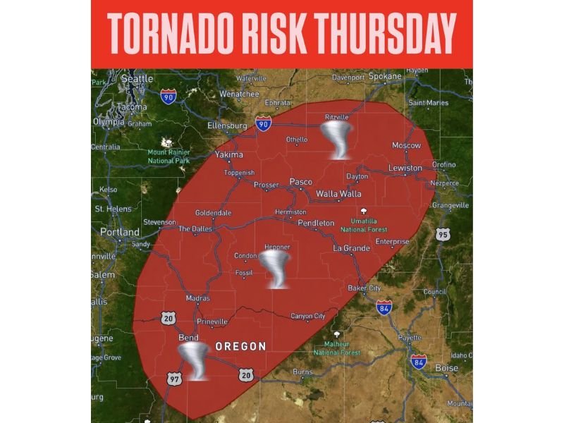
The highlighted risk zone stretches from near Bend and Madras northward through Pendleton, Hermiston, Walla Walla, and toward the Ritzville corridor, making this an unusually significant severe weather setup for a region that rarely sees organized tornado threats.
Rare Tornado Threat Active From Central Oregon Through Southeast Washington Thursday
The tornado risk zone covers an expansive red corridor from central Oregon through southeastern Washington, with tornado icons depicted near Bend, Heppner, and Ritzville reflecting the three primary zones of greatest concern. While the probability remains low end, the mere existence of a tornado risk across the Pacific Northwest is a meteorologically rare event demanding serious attention from all residents within the zone.
A couple of brief weak tornadoes are possible across parts of Oregon and Washington as the setup delivers just enough shear and instability to support organized rotation within stronger storm cells through the afternoon and evening hours.
Damaging Winds and Large Hail Remain the Primary Hazards Across the Entire Risk Zone
While the tornado threat headlines the story for its rarity, damaging winds and large hail remain the higher probability hazards across the risk zone Thursday. Stronger cells developing across Pendleton, Hermiston, The Dalles, and Walla Walla will be capable of producing significant wind gusts and hail through the afternoon and evening period.
Residents across the entire red risk zone from Bend northward through Pendleton and into southeastern Washington should treat Thursday afternoon as a genuine severe weather day regardless of the low tornado probability.
Shelter Plans Required for All Communities Within the Risk Zone Thursday Afternoon
Anyone across Bend, Madras, Prineville, Pendleton, La Grande, and Walla Walla should identify a shelter location and monitor local severe weather alerts closely through Thursday afternoon and evening. The rare nature of this Pacific Northwest tornado setup makes preparedness especially critical for a region unaccustomed to organized tornado threats. Stay with NapervilleLocal.com for the latest weather updates and local forecast coverage.

I’ve lived in Naperville long enough to see how quickly our community changes — from new developments downtown to sudden shifts in our Midwest weather. Reporting on Naperville news and daily forecasts gives me the chance to keep neighbors informed about what really matters. My goal is simple: deliver clear, timely updates so you always know what’s happening in our city and what to expect from the skies above.