
Unusual Risk Level 2 Severe Weather With Supercells, Large Hail, Damaging Winds, and Tornado Potential Targeting Washington, Oregon, and Idaho Thursday May 28
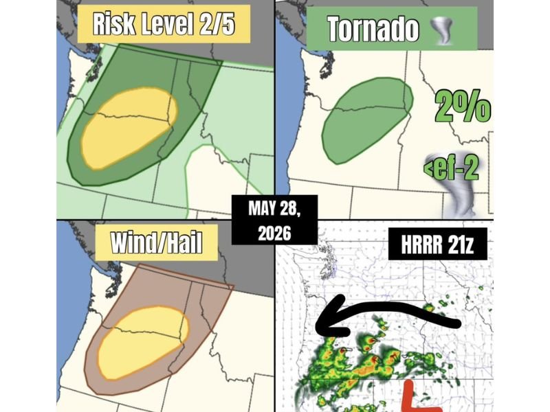
WASHINGTON, OREGON, AND IDAHO — An unusual and rare severe weather setup is unfolding across Washington, Oregon, and Idaho on Thursday, May 28, 2026, as a cutoff low to the south rotates supercell-capable storms around its back side into the Pacific Northwest region. The setup carries a Risk Level 2 out of 5 designation with large hail and damaging winds as the primary hazard modes, while supercell development expected at least initially in the event brings a 2 percent tornado probability with any tornado remaining below EF-2 intensity.
Cutoff Low Driving Unusual Supercell Setup Across the Pacific Northwest Thursday
A cutoff low pressure system located to the south is the driving atmospheric feature behind today’s unusual severe weather placement, rotating storm energy around its back side and directing it into Washington, Oregon, and Idaho. This is a notably rare severe weather configuration for this region at this time of year, making it a meteorologically significant and closely watched event.
Supercells are expected to develop at least during the initial stages of the event, providing the organized storm mode needed to support all hazard modes including wind, hail, and tornado potential. The HRRR 21z model simulation confirms active storm development underway across the region with organized cores tracking into the risk zone.
Large Hail and Damaging Winds the Primary Hazards Across the Level 2 Risk Zone
Large hail and damaging winds are identified as the dominant severe weather hazards across the Level 2 risk zone covering the highlighted corridor through Oregon and into southern Washington and western Idaho. The wind and hail risk zone mirrors the broader Level 2 area, with the highest probability of significant hail and wind damage concentrated within the yellow core zone.
Residents across the primary risk corridor should protect vehicles and outdoor property before storm development intensifies through the afternoon and evening hours Thursday.
Two Percent Tornado Probability Keeps the Spinny Danger Noodle Risk Real Thursday
The 2 percent tornado probability across the green tornado risk zone covering Oregon and southern Washington represents a low but real threat for brief weak tornadoes below EF-2 intensity. Having a shelter plan ready and staying connected to local severe weather alerts through Thursday afternoon and evening is critical for all residents across the affected zone. Stay with NapervilleLocal.com for the latest weather updates and local forecast coverage.

I’ve lived in Naperville long enough to see how quickly our community changes — from new developments downtown to sudden shifts in our Midwest weather. Reporting on Naperville news and daily forecasts gives me the chance to keep neighbors informed about what really matters. My goal is simple: deliver clear, timely updates so you always know what’s happening in our city and what to expect from the skies above.