
Isolated to Scattered Storm Chances South of a Frontal Boundary Across the Central and Southern US Including Dallas, Oklahoma City, and Nashville With Kentucky
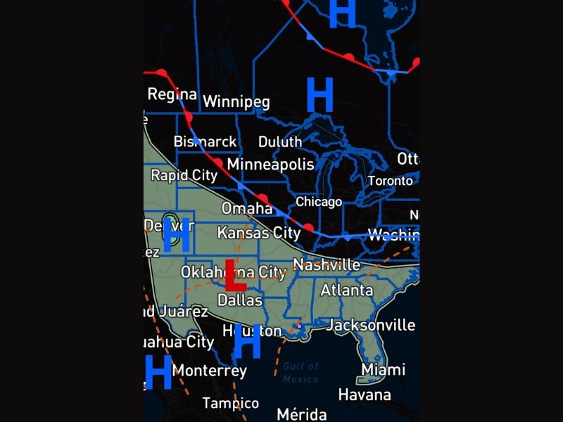
CENTRAL AND SOUTHERN UNITED STATES — A frontal boundary draped across the central United States is separating storm chances between regions on Thursday, May 28, 2026, with everyone south of the front carrying isolated to scattered storm possibilities while areas north of the boundary remain largely dry under high pressure influence. A low pressure center positioned near Oklahoma City is the focal point for storm development south of the front, while Kentucky’s storm chances are described as extremely low despite the state having been in need of meaningful rainfall recently.
Frontal Boundary Dividing Storm Chances From Dry Conditions Across the Central US
The surface analysis shows a cold front draped from the upper Midwest southwestward through Kansas City and into the southern Plains, clearly separating the storm-favorable environment to the south from the high pressure dominated conditions to the north. A strong high pressure system sitting over Canada and extending into the northern Plains and Upper Midwest is keeping conditions dry and settled across a large portion of the country north of the boundary.
Communities south of this frontal line from Dallas through Oklahoma City, Nashville, Atlanta, and Jacksonville all carry at least a chance for isolated to scattered storm development through the day as the low pressure center near Oklahoma City helps focus storm initiation across the region.
Low Pressure Near Oklahoma City Serving as Focal Point for Storm Development Thursday
The surface low positioned near Oklahoma City will play a key role in organizing storm development across the southern Plains and surrounding states through Thursday. Warm and moist air south of the frontal boundary combined with the low pressure circulation creates the lift needed to initiate convection across the corridor from Dallas northward through Oklahoma City and into the Tennessee and Georgia zones.
Storm coverage will be isolated to scattered in nature rather than widespread, meaning hit or miss rainfall distribution will be the story for most communities south of the front through the day.
Kentucky Storm Chances Extremely Low Despite Recent Dry Conditions and Rainfall Need
Despite sitting in a region that has been in need of decent rainfall, Kentucky’s storm chances on Thursday are described as extremely low given its position near and along the frontal boundary. The state’s placement relative to the front limits its access to the unstable air mass needed to support meaningful storm development through the day. Stay with NapervilleLocal.com for the latest weather updates and local forecast coverage.

I’ve lived in Naperville long enough to see how quickly our community changes — from new developments downtown to sudden shifts in our Midwest weather. Reporting on Naperville news and daily forecasts gives me the chance to keep neighbors informed about what really matters. My goal is simple: deliver clear, timely updates so you always know what’s happening in our city and what to expect from the skies above.