
EF-2 Plus Tornado Risk Outlined Across Central Kansas and Nebraska Including Wichita and Rapid City Corridor With Tornado Probabilities Reaching Into the Green Zone Saturday
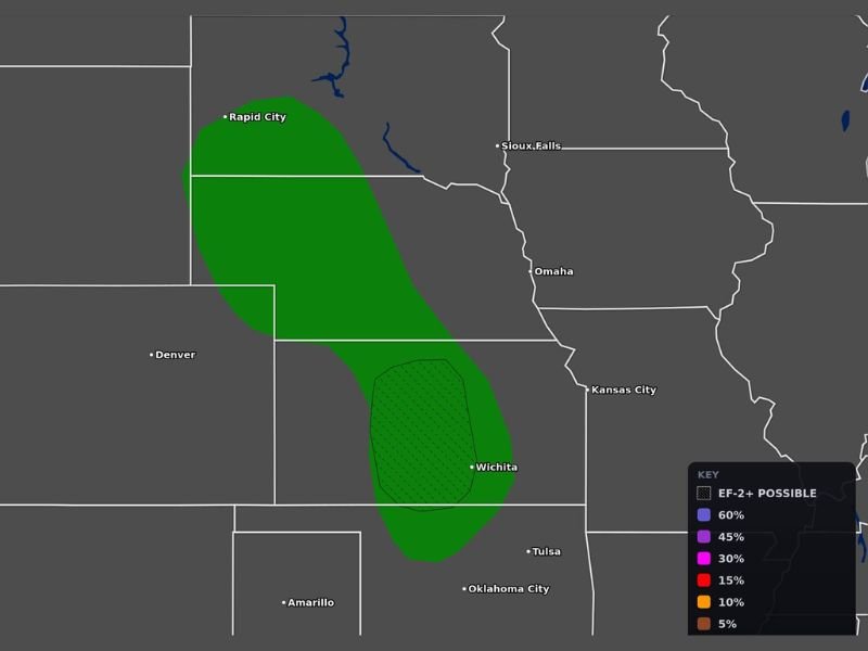
CENTRAL PLAINS — For the first time in a significant stretch, an EF-2 or greater tornado risk zone has been outlined across the central Plains on Saturday, May 30, 2026, with Max Velocity Weather tornado probability maps updated at 2:08AM ET showing a notable green probability corridor stretching from near Rapid City southward through Nebraska and into central Kansas centered near Wichita. The EF-2 plus hatched zone positioned over central Kansas near Wichita represents the area of greatest concern for a significant and potentially long-track tornado event Saturday.
EF-2 Plus Tornado Zone Centered Near Wichita as the Highest Risk Area Saturday
The hatched EF-2 plus designation centered near Wichita and central Kansas identifies this corridor as the most significant tornado threat area on today’s probability map. This hatched zone indicates meteorologists believe there is a meaningful probability that any tornado developing in this area could reach EF-2 intensity or stronger, representing a potentially devastating and life-threatening storm scenario.
The atmospheric ingredients of wind shear, instability, and moisture converging across central Kansas today are providing the recipe for supercell development capable of sustaining long-track and intense tornado potential through the afternoon and evening hours.
Green Tornado Probability Corridor Stretches From Rapid City Through Nebraska Into Kansas
The broader green tornado probability zone extends from near Rapid City in South Dakota southward through the Nebraska Panhandle and eastern Nebraska corridor before widening and intensifying across central Kansas near Wichita. This elongated risk zone covers a wide geographic footprint across multiple states, placing communities from the Rapid City area through Omaha and into the Kansas City metro within the outer reaches of the tornado probability envelope.
Residents across the entire green corridor should treat Saturday as a serious tornado threat day with shelter plans identified and weather alert systems activated well before afternoon storm development begins.
First Significant EF-2 Plus Risk in a While Demands Heightened Preparedness Saturday
The notable aspect of today’s setup is the EF-2 plus designation which forecasters note has not been outlined for a while across this region. This elevated intensity threshold means the tornado threat today goes beyond brief and weak activity and carries genuine potential for significant and destructive tornadoes.
All residents across the central Kansas and Nebraska risk zone should be on high alert through Saturday afternoon and evening. Stay with NapervilleLocal.com for the latest weather updates and local forecast coverage.

I’ve lived in Naperville long enough to see how quickly our community changes — from new developments downtown to sudden shifts in our Midwest weather. Reporting on Naperville news and daily forecasts gives me the chance to keep neighbors informed about what really matters. My goal is simple: deliver clear, timely updates so you always know what’s happening in our city and what to expect from the skies above.