
Tropical Downpours Gusty Winds and Coastal Flooding Threatening Northern Gulf Coast From Louisiana to the Florida Panhandle Thursday and Friday With Gulf Disturbance Developing
NORTHERN GULF COAST — A Gulf Watch is in effect as a weak area of low pressure attempts to spin up at the tail end of a decaying cold front over the Gulf of Mexico later this week, bringing tropical feeder bands, heavy rainfall, wind gusts of 30 to 40 mph, coastal flooding, and dangerous rip currents to the northern Gulf Coast from Louisiana through the Florida Panhandle on Thursday and Friday.
Tropical development chances remain low at this time, but the National Hurricane Center is expected to mention this area in the coming days as conditions are monitored. Regardless of whether a tropical depression forms, the coastal impacts are expected to be significant through the late week period.
Heavy Rain and Wind Gusts of 30 to 40 MPH Expected Along the Coastline
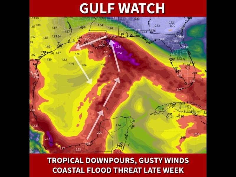
Tropical feeder bands associated with the Gulf disturbance will push heavy rainfall totals of 2 to 2.5 inches or higher across the northern Gulf Coast, with the precipitation map showing deep red and purple shading concentrated along the Louisiana and Mississippi coastline through the Florida Panhandle.
Wind gusts of 30 to 40 mph will accompany the squall activity, making coastal travel and outdoor activities hazardous through the Thursday and Friday window. The onshore fetch of wind will compound coastal impacts significantly regardless of whether the system achieves tropical classification.
Coastal Flooding and Dangerous Rip Currents Pose Serious Beach Hazards
The onshore wind flow generated by the Gulf disturbance will drive coastal flooding concerns and extremely dangerous rip current conditions along Gulf-facing beaches from Louisiana through the Florida Panhandle. Beachgoers should avoid entering the water entirely through the late week period as rip current risks reach life-threatening levels. Low-lying coastal areas should also monitor conditions for potential tidal flooding as the onshore fetch of wind pushes water inland through Thursday and Friday.
Conditions Improve Heading Into the Weekend as Disturbance Moves Inland
The good news is that weather conditions along the northern Gulf Coast are expected to improve heading into the weekend as the Gulf disturbance tracks inland and weakens. The first named storm of the 2026 Atlantic hurricane season would be Arthur if the system achieves tropical storm status. Residents along the coast should remain vigilant through Friday before the gradual improvement arrives. Stay with NapervilleLocal.com for the latest weather updates and local forecast coverage.

I’ve lived in Naperville long enough to see how quickly our community changes — from new developments downtown to sudden shifts in our Midwest weather. Reporting on Naperville news and daily forecasts gives me the chance to keep neighbors informed about what really matters. My goal is simple: deliver clear, timely updates so you always know what’s happening in our city and what to expect from the skies above.