
Damaging Winds Large Hail and Tornado or Two Targeting Northern Plains Including Sioux Falls Rapid City and Minneapolis With Widespread Storms Wednesday June 3rd
NORTHERN PLAINS — Widespread severe storms are forecast across the Northern Plains Wednesday June 3rd, carrying damaging winds, large hail, and the potential for a tornado or two across a corridor that includes Sioux Falls, Rapid City, and the broader Dakotas region under a Slight Risk designation.
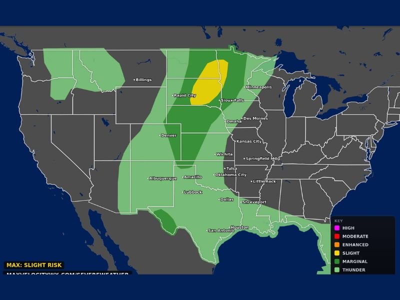
The categorical outlook issued by Max Velocity Weather places a yellow Slight Risk zone centered over the eastern Dakotas and extending toward the Minnesota border, surrounded by a broader dark green Marginal Risk footprint stretching from Denver northward through Billings and eastward toward Minneapolis and Omaha. This is a setup capable of producing significant severe weather impacts across a large portion of the central United States.
Yellow Slight Risk Zone Centered Over Eastern Dakotas Near Sioux Falls
The highest risk area for Wednesday is concentrated in the yellow Slight Risk zone positioned over the eastern Dakotas, with Sioux Falls sitting near the center of the greatest threat footprint. This zone carries the most favorable combination of wind shear, instability, and moisture to support organized supercell development capable of producing all three severe hazards. Residents across the eastern Dakotas and western Minnesota border communities should treat Wednesday as a weather-aware day and monitor conditions closely through the afternoon and evening.
Damaging Winds Large Hail and an Isolated Tornado the Three Headline Threats
The three confirmed hazards for Wednesday across the Northern Plains are damaging winds, large hail, and an isolated tornado or two in the most organized storm cells. This type of setup is capable of widespread property damage across a large geographic footprint given the broad coverage of storm activity expected. Anyone with outdoor plans across the Slight or Marginal Risk zones Wednesday should have a weather safety plan in place before storms develop during the afternoon hours.
Broad Marginal Risk Footprint Extends From Denver Through Minneapolis and Omaha
The broader dark green Marginal Risk zone covers an expansive area from Denver and Rapid City northward through Billings and eastward toward Minneapolis, Des Moines, Omaha, and Kansas City. Communities across this entire zone carry at least a low-end severe weather threat Wednesday and should remain weather-aware through the day. The storm coverage is expected to be widespread rather than isolated, increasing the overall impact potential across the Northern Plains.
Stay with NapervilleLocal.com for the latest weather updates and local forecast coverage.

I’ve lived in Naperville long enough to see how quickly our community changes — from new developments downtown to sudden shifts in our Midwest weather. Reporting on Naperville news and daily forecasts gives me the chance to keep neighbors informed about what really matters. My goal is simple: deliver clear, timely updates so you always know what’s happening in our city and what to expect from the skies above.