
Heavy Rain Gusty 30 to 40 MPH Winds Coastal Flooding and Rip Currents Threatening Gulf Coast From Louisiana to the Florida Panhandle Thursday Into Friday
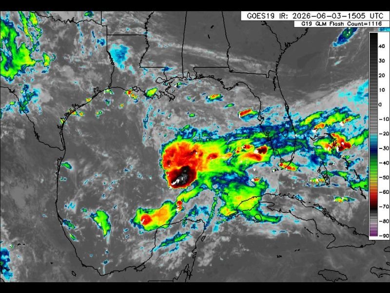
GULF COAST — Tropical rain bands are developing over the Gulf of Mexico Wednesday, with a well-organized disturbance producing intense convection visible on GOES-19 infrared satellite imagery captured at 1505 UTC June 3rd. Tropical development is not expected due to strong wind shear, but the system will still deliver significant coastal impacts regardless of classification.
Heavy rain, gusty winds of 30 to 40 mph or higher, coastal flooding, and dangerous rip currents are all on the table from coastal Louisiana through the Florida Panhandle on Thursday into Friday.
Tropical Rain Bands Already Developing Over the Gulf With Intense Convective Core
The GOES-19 satellite image shows a concentrated area of deep red and white convective tops positioned over the central Gulf of Mexico, indicating an organized and intense area of thunderstorm activity associated with the disturbance. Feeder bands are extending outward from the core toward the Louisiana and Florida Panhandle coastlines as the system interacts with the warm Gulf waters.
Strong wind shear is preventing formal tropical development at this time, but the convective structure is robust enough to produce significant weather impacts along the northern Gulf Coast through the Thursday and Friday window.
Heavy Rain and 30 to 40 MPH Wind Gusts the Primary Threats Along the Coast
Coastal communities from Louisiana through Mississippi, Alabama, and the Florida Panhandle should prepare for periods of heavy rainfall and sustained gusty winds reaching 30 to 40 mph or higher as tropical feeder bands push onshore Thursday into Friday. These wind speeds are sufficient to cause minor property damage, down small tree limbs, and create hazardous driving conditions during the heaviest squalls.
Coastal flooding is also a significant concern as onshore wind flow pushes water into low-lying areas along the immediate coastline.
Dangerous Rip Currents and Coastal Flooding Continue Through Friday Before Improvement Saturday
Life-threatening rip currents will accompany the elevated surf along Gulf-facing beaches from Louisiana through the Florida Panhandle through Friday, and anyone with beach plans should avoid entering the water entirely during this period. Conditions are expected to begin improving on Saturday as the disturbance moves inland and weakens. The first named storm of the 2026 season would be Arthur if the system achieves tropical storm status.
Stay with NapervilleLocal.com for the latest weather updates and local forecast coverage.

I’ve lived in Naperville long enough to see how quickly our community changes — from new developments downtown to sudden shifts in our Midwest weather. Reporting on Naperville news and daily forecasts gives me the chance to keep neighbors informed about what really matters. My goal is simple: deliver clear, timely updates so you always know what’s happening in our city and what to expect from the skies above.