
Two Features to Watch as Non-Developing East Coast Low Departs and Gulf Moisture Blob Brings Heavy Rain Threat to the Upper Gulf Coast Through the Weekend
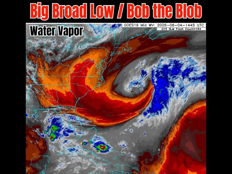
EASTERN UNITED STATES AND GULF COAST — Two distinct weather features are visible on the GOES-19 mid-level water vapor imagery captured at 1445 UTC Thursday June 4th, painting a clear picture of the current atmospheric setup across the eastern half of the country. A large and broad low-pressure system is spinning off the East Coast and tracking northeast, posing no development threat but drawing attention on satellite imagery with its impressive swirling circulation pattern.
Meanwhile a separate Gulf moisture disturbance nicknamed Bob the Blob remains stationary over the Gulf and is not developing, but will push its moisture northward into the upper Gulf Coast over the next couple of days.
Big Broad Low Off the East Coast Heading Northeast With No Development Threat
The large broad low visible on the water vapor image is positioned off the eastern seaboard and tracking away from the coast toward the northeast. Earlier ensemble model runs had briefly flagged this feature as something to monitor, but it has not organized and poses no tropical development concern at this time.
The swirling dry slot and circulation on the satellite image are visually striking, but the system is simply a non-tropical low exiting the region and will have no direct weather impact on the continental United States going forward.
Bob the Blob Remains in the Gulf and Is Not Developing Tropically
The Gulf moisture disturbance remains disorganized over the central Gulf of Mexico and is not showing signs of tropical development at this time. Despite lacking tropical organization, the disturbance is loaded with deep tropical moisture that will be funneled northward toward the upper Gulf Coast over the next couple of days.
This moisture infusion will maintain the heavy rain, gusty wind, and coastal flooding threat across Louisiana through the Florida Panhandle through the end of the week.
Gulf Moisture Delivery to Continue Impacting the Northern Gulf Coast Through the Weekend
As Bob the Blob pushes its juice northward into the upper Gulf, communities from coastal Louisiana through Mississippi, Alabama, and the Florida Panhandle should expect continued rounds of heavy rainfall and squally conditions through the weekend. Conditions are expected to gradually improve as the disturbance eventually weakens and moves inland. No tropical development is anticipated from either feature currently on the water vapor map.
Stay with NapervilleLocal.com for the latest weather updates and local forecast coverage.

I’ve lived in Naperville long enough to see how quickly our community changes — from new developments downtown to sudden shifts in our Midwest weather. Reporting on Naperville news and daily forecasts gives me the chance to keep neighbors informed about what really matters. My goal is simple: deliver clear, timely updates so you always know what’s happening in our city and what to expect from the skies above.