
Early Summer Heat Building Into the Mid 80s to Low 90s Across Colorado Including Denver Front Range Western Slope and Eastern Plains With Widespread 90s Arriving This Weekend
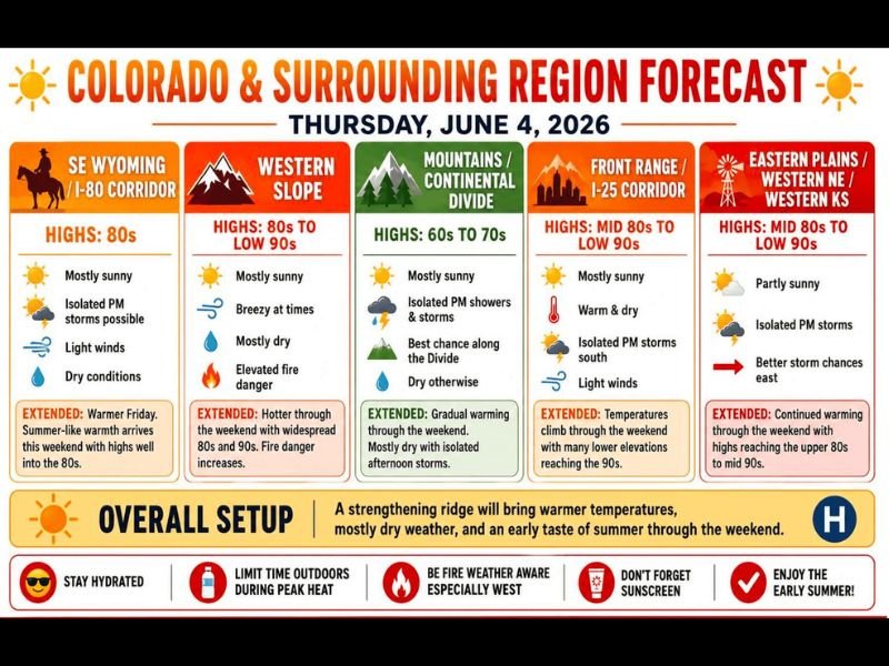
COLORADO AND SURROUNDING REGION — A strengthening ridge is building across Colorado and the surrounding region Thursday June 4th, delivering an early taste of summer with highs reaching the mid 80s to low 90s across the Front Range, western slope, and eastern plains. The overall setup is mostly sunny and dry across the majority of zones, with only isolated afternoon storm chances confined to the Mountains and Continental Divide area.
The big story is the weekend heat surge, with widespread 90s expected Saturday and Sunday and Denver forecast to hit 93 degrees Saturday and 92 Sunday.
Front Range and Eastern Plains Reach Mid 80s to Low 90s Thursday
The Front Range I-25 corridor and eastern plains into western Nebraska and western Kansas are both forecast to reach mid 80s to low 90s Thursday under mostly sunny skies with light winds. Conditions are described as warm and dry along the Front Range with only isolated afternoon storm chances pushed south. The eastern plains carry slightly better storm chances developing eastward through the afternoon but the dominant story remains the building heat.
The western slope also reaches the 80s to low 90s Thursday with mostly dry conditions and elevated fire danger developing as the ridge strengthens.
Widespread 90s Take Over This Weekend With Denver Hitting 93 Saturday
The heat ramps up significantly heading into the weekend as the strengthening ridge delivers widespread 90s across virtually every zone from the western slope through the eastern plains. Denver is forecast to reach 93 degrees Saturday and 92 on Sunday, with many lower elevation communities along the Front Range and eastern plains matching or exceeding those readings.
Fire danger will increase significantly across the western slope through the weekend as hot, dry, and at times breezy conditions combine.
Heat Safety Critical Through the Weekend as Temperatures Peak
Forecasters are strongly advising residents to stay hydrated, limit outdoor time during peak afternoon heat, apply sunscreen, and remain fire weather aware especially across the western portions of the state. The heat core is expected to back off slightly into the 80s by Monday before potentially surging again Tuesday through Thursday of next week. Stay with NapervilleLocal.com for the latest weather updates and local forecast coverage.

I’ve lived in Naperville long enough to see how quickly our community changes — from new developments downtown to sudden shifts in our Midwest weather. Reporting on Naperville news and daily forecasts gives me the chance to keep neighbors informed about what really matters. My goal is simple: deliver clear, timely updates so you always know what’s happening in our city and what to expect from the skies above.