
Damaging Winds and Large Hail Possible Across Most of Ohio Including Columbus Cleveland Toledo and Dayton With Storms Firing Between 2 PM and Midnight Saturday
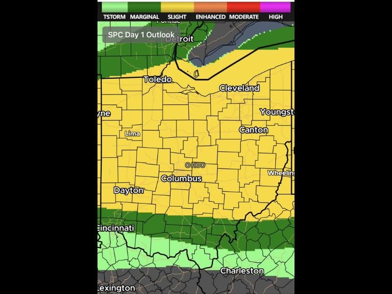
OHIO — A Level 2 Slight Risk of severe weather covers most of Ohio Saturday June 6th, with the SPC Day 1 outlook showing wall-to-wall yellow Slight Risk shading blanketing the state from Toledo and Cleveland southward through Columbus, Dayton, Canton, and Youngstown. Additional storms are likely to fire and move southeast between 2 PM and midnight, bringing the primary severe weather window to the bulk of the state through the evening hours.
This is not a widespread outbreak scenario, but the event is disruptive enough to warrant serious attention for anyone with outdoor plans today.
Main Threats Focused North of US-50 With Damaging Winds and Large Hail
The strongest storm potential is concentrated north of US-50 across Ohio, where damaging winds and large hail are the two headline threats with any organized severe cells. A cluster of storms is already moving into northwest Ohio Saturday morning, though severe weather is unlikely with this initial activity.
The more significant storm development is expected during the 2 PM through midnight window as additional cells fire and push southeast across the Slight Risk zone.
Extremely Low Tornado Threat Exists Across Central and Eastern Ohio
An extremely low tornado threat exists across central and eastern Ohio today, though forecasters are emphasizing that most if not all storms are expected to fail to achieve tornado production status. Any tornado that does occur would be low intensity and very brief in duration.
The primary focus remains squarely on damaging winds and large hail rather than tornado activity for the vast majority of the state Saturday.
Have Multiple Ways to Receive Warnings Before the 2 PM Storm Window Opens
With the most active storm period running from 2 PM through midnight, residents across Ohio are urged to have active ways to receive severe weather warnings well before the afternoon hours arrive. A weather alert app with notifications enabled is essential on a day with this level of outdoor activity statewide.
Not every storm will be severe and some locations may see little impact, but preparedness across the full Slight Risk zone is the right approach today. Stay with NapervilleLocal.com for the latest weather updates and local forecast coverage.

I’ve lived in Naperville long enough to see how quickly our community changes — from new developments downtown to sudden shifts in our Midwest weather. Reporting on Naperville news and daily forecasts gives me the chance to keep neighbors informed about what really matters. My goal is simple: deliver clear, timely updates so you always know what’s happening in our city and what to expect from the skies above.