
Enhanced Risk Level 3 Severe Weather Threatens the Stateline Region Including Rockford and Chicago With 75+ MPH Winds and Tornadoes Possible This Afternoon Into Tonight
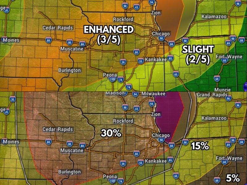
STATELINE REGION — The severe weather threat remains firmly on the table for the entire Stateline region this Wednesday, with a Level 3 of 5 Enhanced Risk in place for today and tonight. Storm chances are expected to begin as early as early afternoon, with a potentially second round arriving during the evening hours. Any storm that develops will carry the potential to become severe given the significant atmospheric energy in place.
Gusty Winds Topping 75 MPH Are the Greatest Threat Today
The primary severe weather hazard today is damaging wind gusts potentially exceeding 75 mph. Afternoon storms are expected to be more cellular in nature before transitioning into a more linear storm complex through the evening, at which point gusty winds become the dominant severe weather mode.
The damaging wind risk maps show a 30% probability across the Rockford corridor, dropping to 15% near Chicago. Residents across the Stateline should prepare for potential power outages and avoid being outdoors during the most active storm windows.
Tornado Threat Highest West of Rockford Into Northwestern Illinois
Tornadoes are possible today, particularly in the far northwestern portion of the state. The cellular storm mode during the afternoon hours allows storms to rotate more easily, increasing the tornado potential before the linear transition occurs later in the evening.
Tornado risk probabilities show 10% across areas near Madison and Milwaukee, with 5% near the Rockford and Zion area, and 2% near Chicago. Stronger tornadoes are possible, especially the farther west you are from Rockford. Have a shelter plan ready before storms arrive this afternoon.
Large Hail and Multiple Storm Rounds Also Possible
While hail is not the primary concern today, large hail remains possible with the strongest storms. Hail risk probabilities sit at 30% near the Rockford area and 15% near Chicago. The Precisioncast model indicates storm activity developing by 2:00 PM Wednesday, with the potential for an additional evening round keeping the threat elevated well into tonight. Stay with NapervilleLocal.com for the latest weather updates and local forecast coverage.

I’ve lived in Naperville long enough to see how quickly our community changes — from new developments downtown to sudden shifts in our Midwest weather. Reporting on Naperville news and daily forecasts gives me the chance to keep neighbors informed about what really matters. My goal is simple: deliver clear, timely updates so you always know what’s happening in our city and what to expect from the skies above.