
Dangerous Heat, Gusty Winds, and Critical Fire Danger Sweep Colorado, Western Kansas, and Western Nebraska With Near-100° Temps and Isolated Strong Storms Possible After Dark
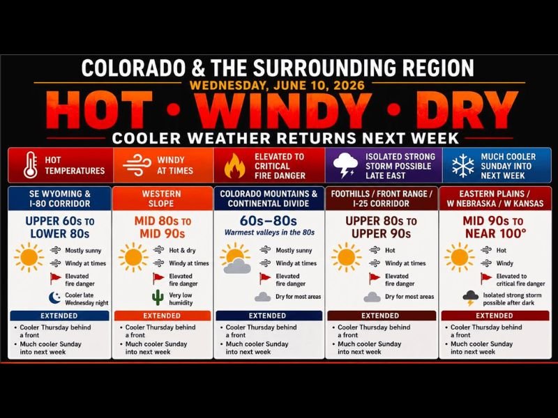
COLORADO — A dangerous combination of extreme heat, gusty winds, and critically low humidity is creating elevated to critical fire weather conditions across Colorado and the surrounding region this Wednesday. Temperatures are soaring into the 80s and 90s for most areas, with the hottest readings across the eastern plains, western Nebraska, and western Kansas where a few locations could approach 100 degrees, particularly south of I-70.
Eastern Plains and Western Kansas Facing the Worst Heat and Fire Danger
The most intense conditions today are focused across the Eastern Plains, western Nebraska, and western Kansas, where temperatures are forecast in the mid-90s to near 100°F. Elevated to critical fire danger is in effect for this zone, with hot temperatures, gusty winds, and very low humidity combining to create fast-spreading fire conditions.
Anyone in these areas should avoid any activity that could produce a spark outdoors. Do not leave children or pets in vehicles, and stay hydrated throughout the day.
Front Range, Foothills, and Western Slope Also Facing Heat and Wind
Across the Foothills, Front Range, and I-25 Corridor, high temperatures will reach the upper 80s to upper 90s with gusty winds and elevated fire danger. Conditions will be hot and dry with little relief through the afternoon hours.
The Western Slope is forecast to hit mid-80s to mid-90s with very low humidity and gusty winds, also carrying elevated fire danger. Even the SE Wyoming and I-80 Corridor will see upper 60s to lower 80s with elevated fire danger and windy conditions.
Isolated Strong Storms Possible After Dark Ahead of Cold Front
A cold front is expected to arrive late tonight, and as it pushes through, isolated thunderstorms may develop after dark across the eastern plains. While most locations will not see storms, any storm that does develop could briefly become strong.
Relief arrives Thursday with temperatures dropping back into mainly the 70s and 80s, though heat is expected to rebound Friday and Saturday before a more significant cooldown arrives Sunday into next week. Stay with NapervilleLocal.com for the latest weather updates and local forecast coverage.

I’ve lived in Naperville long enough to see how quickly our community changes — from new developments downtown to sudden shifts in our Midwest weather. Reporting on Naperville news and daily forecasts gives me the chance to keep neighbors informed about what really matters. My goal is simple: deliver clear, timely updates so you always know what’s happening in our city and what to expect from the skies above.