
Strong Tornado Area in Effect for Northern Illinois and Southern Wisconsin With EF-2+ Possible and Upgrade Likely as Intense Supercells Target the Region From 3 to 9 PM Today
NORTHERN ILLINOIS/SOUTHERN WISCONSIN — A strong tornado area is in place today, June 11, for northern Illinois and southern Wisconsin, with the primary severe weather window running from 3:00 PM to 9:00 PM. Intense supercells are expected to develop following a morning round of storms, and the extreme shear and instability combination in place today has forecasters watching for a potential upgrade in both coverage and intensity as the afternoon unfolds.
Northern Illinois and Southern Wisconsin Most Favored for Strong Tornadoes
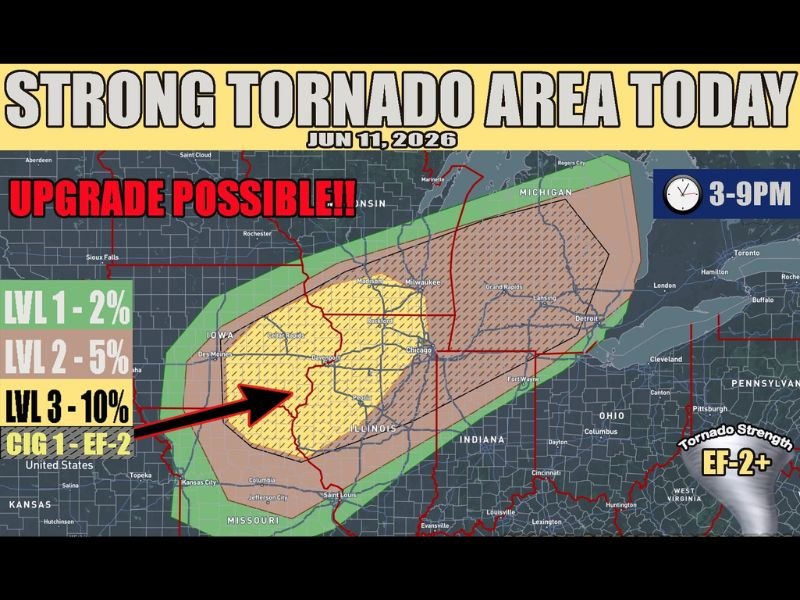
Northern Illinois and southern Wisconsin are identified as the most favored areas for strong tornado development today. The core tornado probability zone sits at Level 3 with a 10% tornado probability, and the current setup supports tornadoes potentially reaching EF-2 or stronger — labeled as CIG 1 EF-2 on the outlook graphic.
Forecasters have noted that an upgrade to Level 4 CIG 2 EF-3 is explicitly possible later today once the morning storm details become clearer and the warm sector boundary is better defined. Residents across this corridor must be in or near shelter before 3:00 PM.
Morning Storms Will Dictate Where Tornado Potential Is Greatest
A morning round of storms featuring potentially significant elevated hail is moving through the region ahead of the main event. Where those morning storms track will directly influence how the warm sector sets up, which in turn determines where the greatest tornado potential will be focused this afternoon.
The main severe weather round is expected to get going around 3:00 PM, with intense supercells developing in an environment characterized by extreme shear and instability. Any sustained supercell that develops in this environment carries a high probability of producing a significant tornado.
Upgrade to EF-3 Tornado Threat Possible as Details Come Into Focus
The overall setup today warrants serious attention. The environment supports upgrades in both storm coverage and tornado intensity through the afternoon hours. Forecasters are watching closely and additional updates are expected before the main window opens.
Do not delay shelter plans waiting for a warning — when the tornado sirens sound, act immediately. Stay with NapervilleLocal.com for the latest weather updates and local forecast coverage.

I’ve lived in Naperville long enough to see how quickly our community changes — from new developments downtown to sudden shifts in our Midwest weather. Reporting on Naperville news and daily forecasts gives me the chance to keep neighbors informed about what really matters. My goal is simple: deliver clear, timely updates so you always know what’s happening in our city and what to expect from the skies above.