
Historic SigTor Parameter Hits Top of Charts Across Northern Illinois and Southern Wisconsin Signaling an Extreme Tornado Environment This Thursday Afternoon
NORTHERN ILLINOIS/SOUTHERN WISCONSIN — A 9 AM Thursday update is raising the alarm to the highest level for severe weather and tornado potential across northern Illinois and southern Wisconsin this afternoon. The Significant Tornado Parameter, known as SigTor, which combines all the key atmospheric ingredients needed for tornadoes, has reached the top of the charts today — a scenario that occurs only once every few years. Forecasters are not sugarcoating the threat: the ceiling for severe weather late today is described as through the roof.
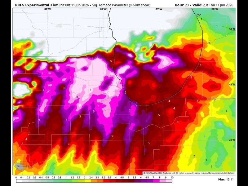
SigTor Values at Historic Levels — A Once-Every-Few-Years Setup
The SigTor parameter is a composite index that measures the combination of wind shear, instability, moisture, and storm-relative helicity simultaneously. When all of those ingredients align at maximum levels, the SigTor reaches extreme values — and that is exactly what models are showing today across this region.
Both the Hour 18 and Hour 23 model runs valid for Thursday afternoon and evening show an expansive zone of deep purple and pink SigTor values exceeding 6 to 10+ across northern Illinois and into southern Wisconsin. Values this high are extraordinarily rare and signal an environment that is primed for significant tornado production.
High SigTor Does Not Guarantee Tornadoes — But the Ceiling Is Extreme
Forecasters are careful to note that even off-the-charts SigTor values do not guarantee a tornado will occur. What these values do confirm is that the atmospheric environment today is as favorable for significant tornado development as it gets.
If supercells can sustain themselves within this environment this afternoon, the probability of tornado production — and potentially strong, long-track tornadoes — increases dramatically. The question is not whether the environment supports tornadoes, but whether storm mode allows discrete supercells to take advantage of it.
Take This Threat Seriously Before the Afternoon Window Opens
With SigTor values this extreme, there is no room for complacency across northern Illinois and southern Wisconsin today. The primary severe weather window opens this afternoon and extends into the evening hours.
Shelter plans must be finalized now, weather alerts must be active, and any tornado warning issued today should be treated with the utmost urgency. Stay with NapervilleLocal.com for the latest weather updates and local forecast coverage.

I’ve lived in Naperville long enough to see how quickly our community changes — from new developments downtown to sudden shifts in our Midwest weather. Reporting on Naperville news and daily forecasts gives me the chance to keep neighbors informed about what really matters. My goal is simple: deliver clear, timely updates so you always know what’s happening in our city and what to expect from the skies above.