
True Summer Humidity Arrives Across Houston and Southeast Texas With Dew Points Soaring Into the Mid-to-Upper 70s as Three Warm Sunny Days Lead Into Rain Chances Sunday
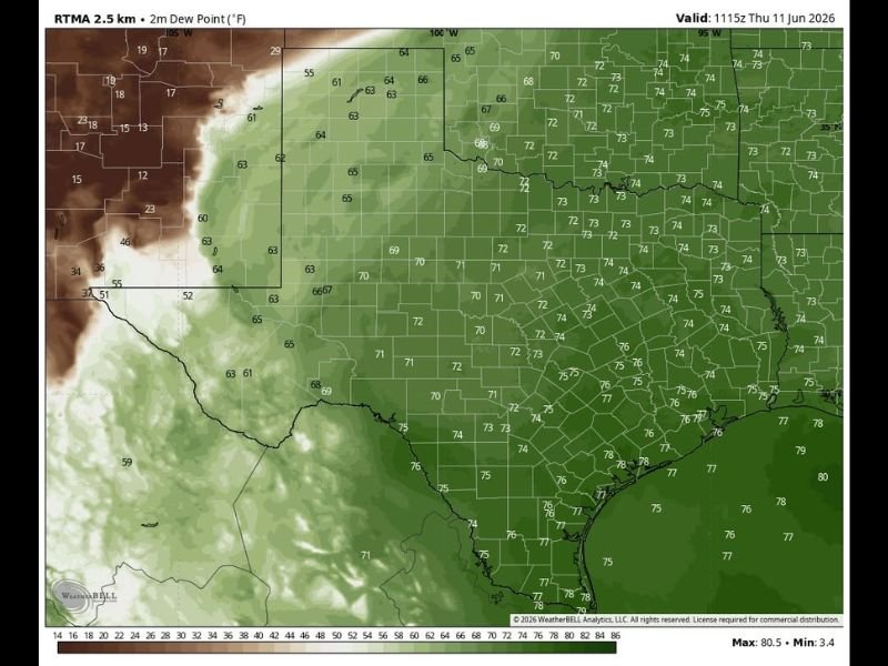
HOUSTON/SOUTHEAST TEXAS — True summer-like humidity has officially arrived across Houston and Southeast Texas, with dew point readings climbing into the mid to upper 70s across the region as of Thursday morning, June 11. The RTMA 2.5km dew point analysis shows values of 75 to 80°F across the Houston metro and coastal Southeast Texas, firmly establishing the sultry and oppressive humidity pattern that defines deep summer across the Gulf Coast.
Dew Points in the Mid-to-Upper 70s Make It Feel Oppressive
The dew point map tells the story clearly. Coastal Southeast Texas and the Houston area are running dew points of 75 to 80°F, with some coastal locations touching 79 and 80°F. Inland areas across central and east Texas are not far behind, with widespread dew points in the 72 to 75°F range.
These dew point levels push the heat index well above actual air temperatures during the afternoon hours, making outdoor activity feel significantly more taxing than the thermometer alone suggests. Staying hydrated and limiting prolonged outdoor exposure during peak afternoon heating is important through this stretch.
Three Warm and Mostly Sunny Days Ahead Before Rain Returns
Despite the oppressive humidity, the next three days are expected to feature warm and mostly sunny conditions across the Houston area. Afternoon temperatures will remain seasonably hot, and the combination of sunshine and high dew points will keep the feel-like temperatures elevated through the weekend.
Rain chances remain limited through Saturday, offering a relatively dry window for outdoor plans despite the heavy moisture in the air.
Widespread Showers Expected Monday and Tuesday Next Week
The pattern shifts heading into next week as rain chances return Sunday and then become widespread on Monday and Tuesday. A more active weather pattern will bring multiple rounds of showers across the region, offering some temporary relief from the heat but also introducing flooding concerns given the already saturated atmospheric moisture levels.
Residents should monitor forecast updates through the weekend as timing and rainfall totals for next week’s wet pattern become clearer. Stay with NapervilleLocal.com for the latest weather updates and local forecast coverage.

I’ve lived in Naperville long enough to see how quickly our community changes — from new developments downtown to sudden shifts in our Midwest weather. Reporting on Naperville news and daily forecasts gives me the chance to keep neighbors informed about what really matters. My goal is simple: deliver clear, timely updates so you always know what’s happening in our city and what to expect from the skies above.