
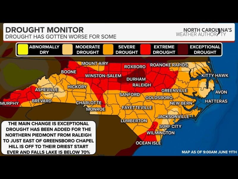
Exceptional Drought Hits Northern Piedmont as Raleigh, Chapel Hill, and Greensboro Face Worst Dryness in Decades With Falls Lake Dropping Below 70% Capacity
NORTH CAROLINA — Drought conditions have worsened significantly across North Carolina’s Northern Piedmont, with Exceptional Drought — the highest level on the scale — now added to the map from Raleigh to just east of Greensboro. Little to no rainfall has fallen across this corridor for weeks, and the combination of high temperatures and relentless sunshine has accelerated drying conditions to historically concerning levels.
Exceptional Drought Now Covers the Raleigh to Greensboro Corridor
The most dramatic deterioration on the latest drought monitor update is centered across the Northern Piedmont. The Exceptional Drought designation now stretches from Raleigh westward to just east of Greensboro, covering a densely populated corridor that includes Durham, Chapel Hill, and surrounding communities.
This is the worst drought category issued by the U.S. Drought Monitor and reflects widespread, long-term moisture deficits that are impacting water supplies, agriculture, and vegetation across the region.
Falls Lake Below 70% as Chapel Hill Records Driest Start Ever
The real-world impacts of the ongoing drought are becoming impossible to ignore. Falls Lake, a critical water supply reservoir serving the Raleigh metro area, has fallen below 70% of its capacity for the first time in decades. Chapel Hill has recorded its driest start to the year on record, underscoring how extraordinary this drought event has become for the region.
Extreme Drought in deep red covers a large portion of central North Carolina including Winston-Salem, Hickory, Charlotte, Sanford, Fayetteville, and Wilmington, with Severe and Moderate Drought conditions extending across much of the remainder of the state.
Only Hit-or-Miss Storm Relief Expected Through the Weekend
Unfortunately, no widespread rainfall relief is in the immediate forecast. The rest of the week into the weekend will bring only isolated to scattered hit-or-miss storms, meaning very localized areas may receive some rainfall while most drought-impacted zones remain dry.
The central section of the state is in critical need of widespread, soaking rainfall to begin reversing these historic drought conditions.
Stay with NapervilleLocal.com for the latest weather updates and local forecast coverage.

I’ve lived in Naperville long enough to see how quickly our community changes — from new developments downtown to sudden shifts in our Midwest weather. Reporting on Naperville news and daily forecasts gives me the chance to keep neighbors informed about what really matters. My goal is simple: deliver clear, timely updates so you always know what’s happening in our city and what to expect from the skies above.