
Tornado Area in Place for Northeast Kansas and Northern Missouri Including Topeka and Kansas City as Supercells and Damaging Winds Threaten Saturday June 13
KANSAS/MISSOURI — A tornado area is in place for Saturday, June 13, across northeast Kansas and northern Missouri, with the greatest tornado potential focused on the Topeka and Kansas City corridor. Scattered storms, including a few supercells, are expected to develop ahead of a cold front during the day, with shear, instability, and favorable boundary orientation supporting a discrete storm mode that maximizes tornado potential before storms eventually line out and damaging winds become the primary hazard.
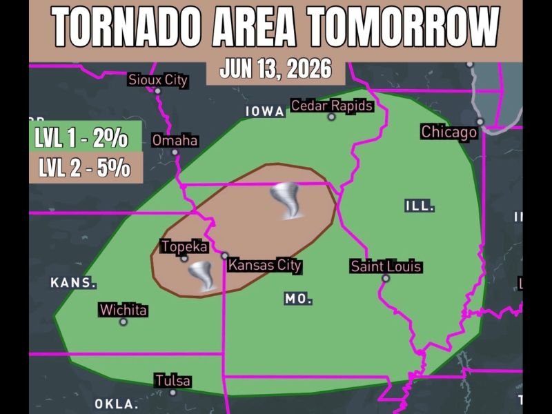
Topeka and Kansas City Corridor Faces Greatest Tornado Potential
The core tornado threat zone — shown in brown on the outlook — is centered directly over northeast Kansas and northern Missouri, encompassing Topeka and Kansas City. This area carries a Level 2 probability of 5% for tornadoes, reflecting a meaningful and focused threat where boundary orientation and atmospheric shear are most favorable for sustaining discrete supercells.
The broader green zone extending across a wider area from Iowa and Nebraska southward through Kansas and Missouri carries a Level 1 probability of 2%, capturing cities including Omaha, Sioux City, Cedar Rapids, and Saint Louis within the outer tornado area.
Supercells Will Favor Discrete Mode Before Lining Out
The setup Saturday favors an initial period of discrete supercell activity, which represents the highest-risk window for tornado production. Shear and instability combinations across the northeast Kansas and northern Missouri area appear most favorable for sustaining individual storm cells long enough to produce tornado potential.
As the afternoon progresses, storms are expected to eventually consolidate and line out into a more linear storm complex. Once that transition occurs, damaging winds become the dominant severe weather mode across the broader region, expanding the impact area well beyond the initial tornado zone.
Damaging Winds Become Primary Threat After Storm Mode Transition
Residents from Topeka and Kansas City eastward through Saint Louis and into Illinois should remain weather aware through the afternoon and evening hours Saturday. While the tornado threat is most concentrated in the brown zone, the wind threat after the linear transition will be widespread.
Have weather alerts active Saturday and know your shelter plan before storms arrive. Stay with NapervilleLocal.com for the latest weather updates and local forecast coverage.

I’ve lived in Naperville long enough to see how quickly our community changes — from new developments downtown to sudden shifts in our Midwest weather. Reporting on Naperville news and daily forecasts gives me the chance to keep neighbors informed about what really matters. My goal is simple: deliver clear, timely updates so you always know what’s happening in our city and what to expect from the skies above.