
Flash Flood Risk Rises for Houston and Galveston as Slight Risk Excessive Rainfall Outlook Targets the Region With Stormier Pattern Arriving Sunday Night Through Tuesday
HOUSTON/GALVESTON — Early summer heat continues across the Houston and Galveston region, but a significant pattern change is on the horizon. The Weather Prediction Center has issued a Day 4 Excessive Rainfall Outlook valid for Monday, June 15, placing Houston and the surrounding region under a Slight Risk for excessive rainfall leading to flash flooding, with a Marginal Risk extending across a broader area of Southeast Texas. A much stormier weather pattern is expected to develop Sunday night and continue through Tuesday.
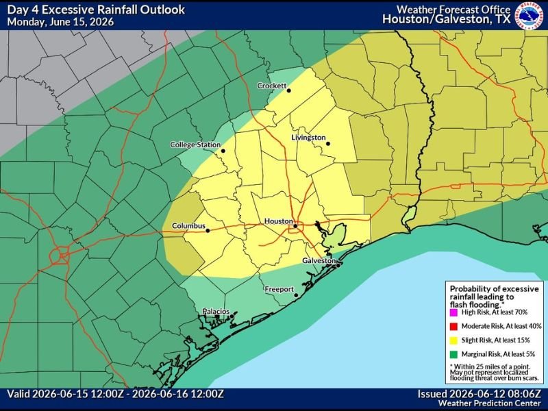
Slight Risk Covers Houston Metro and Surrounding Counties Monday
The Slight Risk zone — carrying at least a 15% probability of excessive rainfall leading to flash flooding within 25 miles of any point — is centered directly over the Houston metro area and extends northward through Livingston and the Piney Woods region, southward toward Galveston and Freeport, and westward toward Columbus.
This coverage area encompasses one of the most flood-prone urban regions in the country. Even a Slight Risk designation in the Houston area warrants close attention given how quickly heavy rainfall can overwhelm drainage systems across Harris County and surrounding communities.
Marginal Risk Extends Across Broader Southeast Texas
A Marginal Risk for excessive rainfall, carrying at least a 5% probability of flash flooding, extends across a much broader swath of Southeast Texas. This zone reaches westward toward College Station and northward through Crockett, capturing a wide area that could see locally heavy rainfall totals during the active weather window.
Residents across all of Southeast Texas should monitor forecast updates closely through the weekend as the stormier pattern develops Sunday night and the flash flood risk becomes better defined.
Heat Continues Through the Weekend Before Pattern Shifts
Ahead of the weekend storm pattern, early summer heat will continue through Saturday across the Houston and Galveston area. Temperatures will remain seasonably hot with high humidity making conditions feel oppressive through the afternoon hours each day.
The window for outdoor activities is best Friday and Saturday before the stormier and wetter pattern arrives Sunday night and intensifies through Monday and Tuesday. Stay with NapervilleLocal.com for the latest weather updates and local forecast coverage.

I’ve lived in Naperville long enough to see how quickly our community changes — from new developments downtown to sudden shifts in our Midwest weather. Reporting on Naperville news and daily forecasts gives me the chance to keep neighbors informed about what really matters. My goal is simple: deliver clear, timely updates so you always know what’s happening in our city and what to expect from the skies above.