
Daily Heavy Rainfall Threat Faces Houston and College Station All Week With Significant Forecast Uncertainty as Storms Track Across Southeast Texas Today
HOUSTON/COLLEGE STATION — Houston and the surrounding Southeast Texas region are facing the threat of heavy rainfall every single day this week, though forecasters are emphasizing significant uncertainty in how this pattern will unfold over the coming days. The setup carries enough nuance that residents are urged to pay close attention to updates rather than relying on a single forecast snapshot, as details could shift considerably day to day.
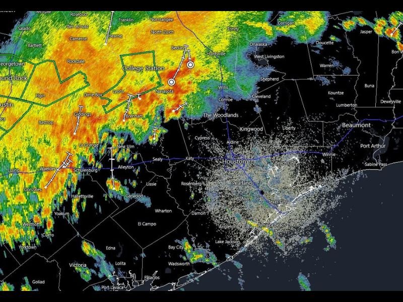
Heavy Storms Already Tracking Across College Station and Brenham Corridor
Current radar shows an extensive area of heavy to intense rainfall stretching across a corridor from Temple and Cameron through College Station, Navasota, Brenham, and Giddings. Several storm cells in this band are producing the deepest red and orange returns on radar, indicating intense rainfall rates capable of quickly adding up to significant totals.
This activity extends northeastward toward Huntsville and Trinity, with additional heavy cores visible near Corrigan and into the Jasper area along the Texas-Louisiana border region.
Houston Metro Seeing Lighter Activity For Now But Daily Rain Expected
The Houston metro area itself is currently seeing lighter activity compared to the intense cores tracking across Central Texas, though daily rainfall threats are expected to persist throughout the week. Areas including Cypress, Katy, Pearland, and Galveston Bay should prepare for the possibility of heavy downpours developing or moving into the area on any given day this week.
Given the daily rainfall threat layered over multiple days, cumulative totals could become significant even if individual days do not produce extreme amounts on their own.
Forecast Uncertainty Means Daily Updates Are Important
Because of the nuance involved in this week’s setup, forecasters are stressing that residents should check forecast updates daily rather than assuming Monday’s outlook will hold for the rest of the week. Timing, placement, and intensity of the heaviest rainfall bands could shift considerably as the week progresses across the Houston and College Station region.
Stay with NapervilleLocal.com for the latest weather updates and local forecast coverage.

I’ve lived in Naperville long enough to see how quickly our community changes — from new developments downtown to sudden shifts in our Midwest weather. Reporting on Naperville news and daily forecasts gives me the chance to keep neighbors informed about what really matters. My goal is simple: deliver clear, timely updates so you always know what’s happening in our city and what to expect from the skies above.