
Strong Tornadoes and 70+ MPH Damaging Wind Gusts Expected Across Missouri, Illinois, and Indiana Under Level 3 Risk for Wednesday All-Hazards Severe Weather Event
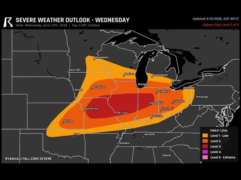
MISSOURI/ILLINOIS/INDIANA — The Storm Prediction Center has placed a Level 3 of 5 Enhanced Risk over Missouri, Illinois, and Indiana for Wednesday, June 17, in what is shaping up to be an all-hazards severe weather day. Storms are expected to fire during the afternoon, first developing as a few strong supercells across Missouri and Illinois before clumping together into one large line as the evening progresses, bringing strong tornadoes early followed by a long swath of damaging wind gusts of 70 mph or more.
Strong Supercells Develop First Across Missouri and Illinois
The setup Wednesday begins with discrete strong supercells expected to fire across Missouri and Illinois during the afternoon hours. This initial phase carries the greatest potential for strong tornadoes, as discrete storm cells in a sheared environment are most capable of producing significant rotation.
The core Level 3 zone, shown in deep red on the SPC outlook, is centered directly over central Illinois and extends into eastern Missouri and western Indiana, covering St. Louis, Kansas City, Indianapolis, and Fort Wayne.
Storms Consolidate Into One Big Line With 70+ MPH Gusts by Evening
As the evening progresses, the individual supercells are expected to clump together into one large line of storms that plows eastward. This transition shifts the primary hazard from tornadoes to a long swath of damaging straight-line winds, with gusts of 70 mph or greater possible along the leading edge of the line.
The broader Level 2 zone surrounding the core extends from Des Moines and Omaha through Chicago, Madison, Detroit, Columbus, and Louisville, reflecting the wide area at risk for damaging winds as the line tracks east.
Setup Has Forecasters’ Attention Two Days Out
While details could still shift considerably as Wednesday approaches, the overall setup has caught forecasters’ attention this far out given the potential for both strong tornadoes early and a significant wind-producing line later. Residents across Missouri, Illinois, and Indiana should monitor forecast updates closely over the next two days.
Stay with NapervilleLocal.com for the latest weather updates and local forecast coverage.

I’ve lived in Naperville long enough to see how quickly our community changes — from new developments downtown to sudden shifts in our Midwest weather. Reporting on Naperville news and daily forecasts gives me the chance to keep neighbors informed about what really matters. My goal is simple: deliver clear, timely updates so you always know what’s happening in our city and what to expect from the skies above.