
Tornadoes, Damaging Winds, and 2 to 3+ Inches of Rain Target Peoria, Springfield, and Champaign Under Moderate Risk as Illinois Severe Weather Outbreak Looms Wednesday
ILLINOIS — Another significant severe weather outbreak is on track for Illinois this Wednesday, with a setup that could rival or exceed last Thursday’s event that produced more than two dozen tornadoes across Illinois, Indiana, and Wisconsin. The greatest tornado threat is focused south of I-88, with a Moderate Risk zone covering Peoria, Bloomington-Normal, Champaign-Urbana, and Springfield, while Chicago and the Stateline face a lower but non-zero tornado risk along the I-88 corridor.
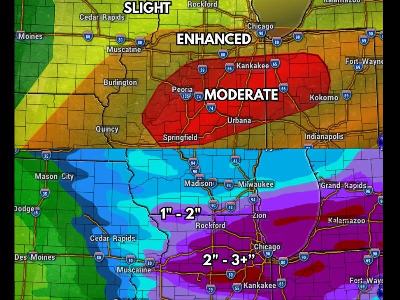
Greatest Tornado Threat South of I-88 Through Central Illinois
The severe weather risk map shows a Moderate Risk zone covering central and south-central Illinois, where tornado potential is highest. Peoria, Bloomington-Normal, Champaign-Urbana, and Springfield are identified as the cities in the greatest tornado risk zone, positioned south of a warm front that will enhance spin in the atmosphere for that area.
The Stateline region sits in a Slight Risk zone, with a non-zero but comparatively smaller tornado threat along the I-88 corridor from Chicago to DeKalb to Dixon and the Quad Cities. Two rounds of storms are expected Wednesday, one in the morning and one in the afternoon.
Damaging Winds Possible Statewide With Hail a Modest Concern
Damaging winds are possible anywhere across the entire state of Illinois and into southern Wisconsin regardless of tornado potential. Hail is listed as a modest concern with any stronger storms that develop during either round Wednesday.
The brief break between the two storm rounds is expected to be quite short, which may limit the atmosphere’s ability to fully destabilize between waves and could temper the tornado threat in the northern part of the state.
Heavy Rainfall Adding Flooding Risk on Top of Severe Weather Threat
On top of the severe weather threat, at least 1 to 2 inches of rain is expected across the Stateline and northern Illinois, with 2 to 3 inches or more possible across central and southern Illinois through 7 AM Thursday. An Excessive Rainfall Marginal Risk is in place, with localized to potentially widespread flooding possible across portions of the state. Stay with NapervilleLocal.com for the latest weather updates and local forecast coverage.

I’ve lived in Naperville long enough to see how quickly our community changes — from new developments downtown to sudden shifts in our Midwest weather. Reporting on Naperville news and daily forecasts gives me the chance to keep neighbors informed about what really matters. My goal is simple: deliver clear, timely updates so you always know what’s happening in our city and what to expect from the skies above.