
Unprecedented Wind Energy Drives Serious Storm Risk Across Kentucky Including Louisville, Lexington, and Bowling Green in Two Rounds Wednesday Evening and Thursday
KENTUCKY — An unprecedented level of wind energy for this time of year is mixing with warm air across Kentucky, setting up a serious storm risk in two distinct rounds — Wednesday evening and again Thursday morning and evening. Forecasters describe the wind energy in place as extraordinary for June, and the combination with warm, unstable air creates an environment capable of producing significant severe weather across the state over the next 36 hours.
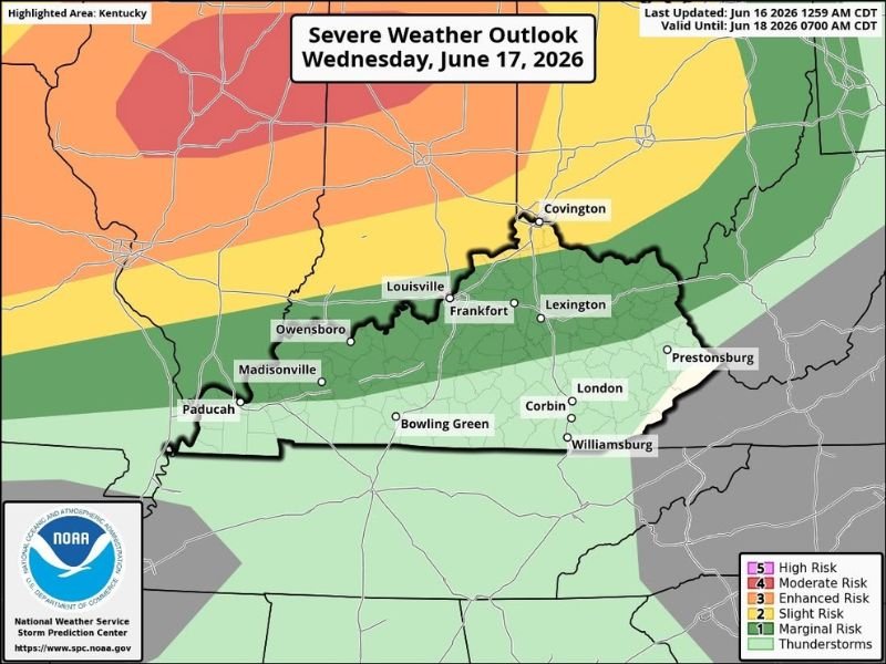
Wednesday Evening Brings the First Round of Serious Storm Risk
The first severe weather window arrives Wednesday evening, with the NOAA severe weather probability maps showing the highest risk corridors shifting across Kentucky during this timeframe. The western portions of the state including Paducah, Madisonville, and Owensboro are positioned in the higher probability zones for the Wednesday evening round, with the risk corridor extending eastward toward Louisville and Frankfort.
The unprecedented wind energy in place means storms that develop will have access to an unusual amount of shear for this time of year, supporting organized and potentially intense storm structures.
Thursday Morning and Evening Bring the Second Round
As more data arrives, Thursday morning and evening are emerging as the two primary time slots for the second round of serious storm potential across Kentucky. The Thursday probability map shows a significantly expanded severe weather risk zone, with the yellow Slight Risk corridor covering virtually the entire state of Kentucky from Paducah through Louisville, Lexington, Bowling Green, Corbin, London, and eastward toward Prestonsburg and Covington.
This second round suggests the storm threat does not end with Wednesday evening but continues into Thursday, making this a multi-round event requiring sustained weather awareness over a 36-plus hour window.
Stay Weather Aware Through Thursday Evening
With two rounds of serious storm potential across Kentucky over the next day and a half, residents should maintain weather awareness through Thursday evening. The combination of unprecedented wind energy and warm unstable air means storms in either round could produce damaging winds, hail, and tornadoes.
Ensure weather alerts are active on all devices and have a shelter plan in place before Wednesday evening storms arrive. Stay with NapervilleLocal.com for the latest weather updates and local forecast coverage.

I’ve lived in Naperville long enough to see how quickly our community changes — from new developments downtown to sudden shifts in our Midwest weather. Reporting on Naperville news and daily forecasts gives me the chance to keep neighbors informed about what really matters. My goal is simple: deliver clear, timely updates so you always know what’s happening in our city and what to expect from the skies above.