
Invest 90L Model Tracks Show Eastward Shift With More Time Over Water Raising Development Odds as System Eyes the Gulf Coast and Southeast Through Midweek
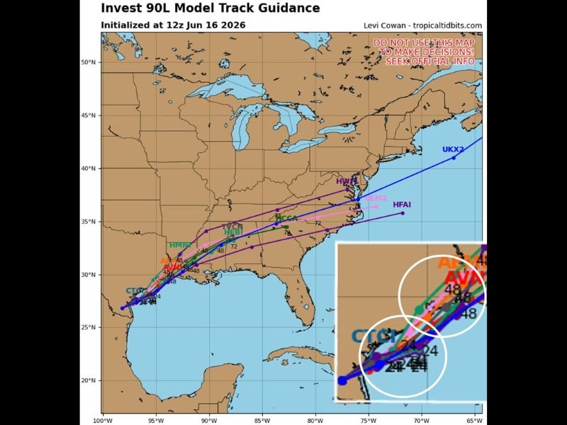
GULF COAST/SOUTHEAST — Tuesday morning’s 12z spaghetti model guidance for Invest 90L, initialized June 16, 2026, is showing a notable eastward push in the track compared to previous runs, with the system spending more time over water before approaching land. This additional time over the Gulf could allow the disturbance to gain some spin and possibly develop further before reaching the Gulf Coast or Southeast U.S. As of the 24-hour timestamp, the system’s center remains over water, with the 48-hour position showing the system approaching the northern Gulf Coast.
Eastward Track Shift Buys More Time Over Water for Potential Development
The model guidance shows a tight cluster of tracks at the 24-hour mark, with models beginning to spread more noticeably by the 48-hour period. The eastward shift compared to prior runs means the system is now tracking closer to the Louisiana, Mississippi, and Alabama coastline rather than making a more direct Texas landfall.
The additional over-water time is the key change in this run, as warm Gulf waters could provide the energy needed for further organization and development of the disturbance before it reaches land.
Model Spread at 48 Hours Reflects Ongoing Uncertainty
While the 24-hour cluster is fairly tight showing the center over water, the 48-hour models show considerable spread, ranging from a Gulf Coast approach on some runs to a track pushing toward the Carolinas and Mid-Atlantic on others. Several models including the HWRF, NEM2, HFAI, and UKX2 suggest a more northeastward track taking the system along or off the Southeast U.S. coastline.
This spread in guidance reflects significant uncertainty that remains in the track and development forecast for Invest 90L.
Seek Official NHC Guidance for All Decisions
Forecasters and model analysts are emphasizing that spaghetti model track graphics should not be used to make any safety or evacuation decisions. All official information on Invest 90L should come directly from the National Hurricane Center, which is the authoritative source for tropical weather guidance and outlooks.
Monitor NHC updates closely as this system evolves through the coming days. Stay with NapervilleLocal.com for the latest weather updates and local forecast coverage.

I’ve lived in Naperville long enough to see how quickly our community changes — from new developments downtown to sudden shifts in our Midwest weather. Reporting on Naperville news and daily forecasts gives me the chance to keep neighbors informed about what really matters. My goal is simple: deliver clear, timely updates so you always know what’s happening in our city and what to expect from the skies above.