
Tornado Outbreak Threatens Peoria, Springfield, Lafayette, and Indianapolis With EF3+ Tornadoes, 2″+ Hail, and 80 MPH Winds Hitting Illinois and Indiana This Wednesday
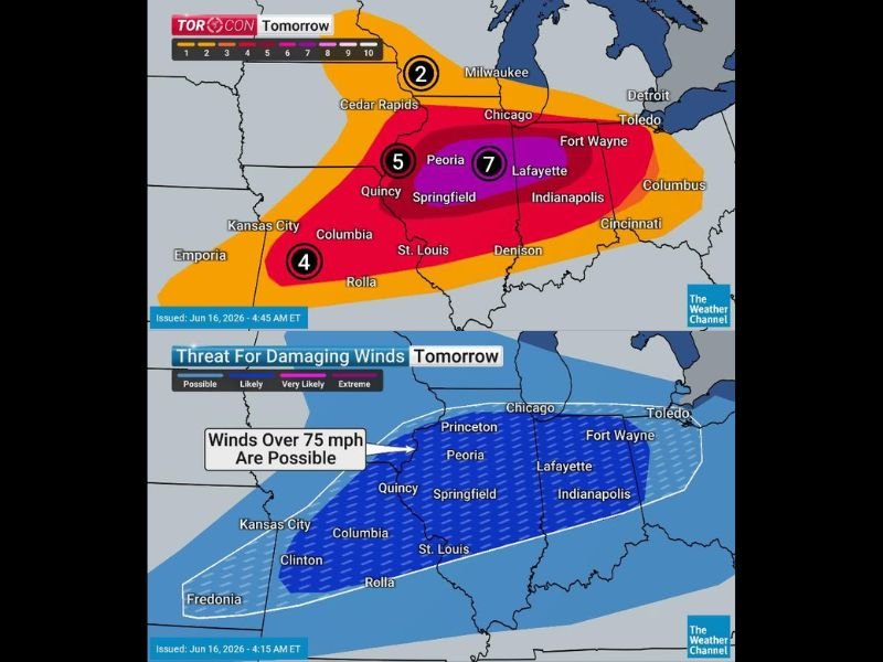
ILLINOIS/INDIANA — The Midwest faces a serious tornado outbreak Wednesday, with TORCON values reaching a 7 across central Illinois and Indiana — one of the highest tornado threat index readings issued for this region in years. Individual supercells across the core zone are capable of producing strong EF2+ tornadoes, with intense EF3+ tornadoes explicitly possible across central Illinois. Large hail of 2 inches or larger in diameter and destructive winds exceeding 80 mph round out a full all-hazards severe weather day.
TORCON 7 Core Zone Covers Peoria, Springfield, Lafayette, and Indianapolis
The highest TORCON value of 7 is centered over a corridor stretching from Peoria and Springfield in Illinois eastward through Lafayette and Indianapolis in Indiana. This zone represents the area with the greatest probability of tornado occurrence Wednesday, and intense EF3+ tornadoes are flagged as possible within this corridor.
A TORCON 5 surrounds this core, covering areas including Quincy, Champaign-Urbana, Bloomington, Watseka, and Monticello, while a TORCON 4 extends westward toward Kansas City, Columbia, and the Missouri corridor. Chicago and the northern zones carry a TORCON 2.
EF3+ Tornadoes Explicitly Flagged for Central Illinois Corridor
The zoomed-in tornado intensity map explicitly labels the central Illinois zone covering Peoria, Bloomington, Champaign-City, Springfield, and extending through Lafayette and Fort Wayne as the area where intense EF3+ tornadoes are possible. This is a rare and serious designation that demands immediate preparation from all residents in this zone.
Even outside this core, any tornado that develops across the broader threat area should be treated as potentially significant.
80 MPH Winds Threaten a Wide Swath From Kansas City Through Indianapolis
The damaging wind threat on Wednesday extends across a very wide corridor from Kansas City, Columbia, and St. Louis through Quincy, Springfield, Peoria, Chicago, Indianapolis, and Fort Wayne. Winds over 75 mph are considered possible across this entire zone as storms organize and push eastward through the afternoon and evening.
Have shelter plans locked in before Wednesday afternoon and treat every tornado warning with life-safety urgency. Stay with NapervilleLocal.com for the latest weather updates and local forecast coverage.

I’ve lived in Naperville long enough to see how quickly our community changes — from new developments downtown to sudden shifts in our Midwest weather. Reporting on Naperville news and daily forecasts gives me the chance to keep neighbors informed about what really matters. My goal is simple: deliver clear, timely updates so you always know what’s happening in our city and what to expect from the skies above.