
Damaging Winds 60 to 70+ MPH and Possible Strong Tornadoes Target Dayton, Lima, and Springfield Ohio Under Enhanced Risk as Severe Line Moves Through Wednesday Night
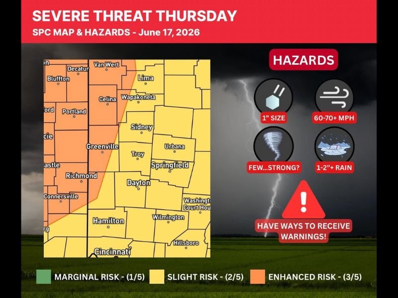
OHIO — An Enhanced Risk (Level 3 of 5) for severe weather is in place for portions of western Ohio this Wednesday night into early Thursday morning, June 17, with a line of storms expected to push through between 10 PM and 4 AM. Damaging winds of 60 to 70+ mph are the primary hazard, with a few strong tornadoes possible and 1 to 2 inches or more of rain also expected. The greatest threat for severe weather remains centered on Illinois and Indiana, but a meaningful risk carries into Ohio with the overnight storm line.
Enhanced Risk Covers Lima, Dayton, and Springfield Corridor
The Enhanced Risk zone covers western Ohio including Lima, Wapakoneta, Celina, Sidney, Greenville, Troy, Springfield, Urbana, Dayton, and Washington Court House. This area faces the highest local probability for damaging wind gusts of 60 to 70+ mph as the storm line pushes through during the overnight hours.
A Slight Risk surrounds this core, extending toward Bluffton, Decatur, Portland, Richmond, Connersville, Hamilton, Wilmington, Hillsboro, and Cincinnati. Even the Marginal Risk fringe carries real severe weather potential given the abnormally strong wind field in place.
Strong Tornado Cannot Be Ruled Out Overnight
While damaging winds are the headline threat, the hazard graphic explicitly flags a few strong tornadoes as possible during the overnight storm window. If the right storm develops out ahead of the main line in a more supercellular mode, winds over 70 mph and a strong tornado could occur within the warning polygon.
The key wildcard locally is how much energy remains after earlier evening storm activity along the warm front. This will directly determine the severity of the overnight line for Ohio.
Have Multiple Ways to Receive Warnings Before Bed Wednesday Night
With the primary storm window running from 10 PM to 4 AM, many residents will be asleep when warnings are issued. Ensure weather alerts are active on all mobile devices and set to wake you from sleep. Hail up to 1 inch in size and 1 to 2 inches of rain are also expected with this system.
Stay with NapervilleLocal.com for the latest weather updates and local forecast coverage.

I’ve lived in Naperville long enough to see how quickly our community changes — from new developments downtown to sudden shifts in our Midwest weather. Reporting on Naperville news and daily forecasts gives me the chance to keep neighbors informed about what really matters. My goal is simple: deliver clear, timely updates so you always know what’s happening in our city and what to expect from the skies above.