
Potential Tropical Cyclone One Eyes Galveston and the Texas Coast With Life-Threatening Flash Flooding, 5 to 20 Inches of Rain, and Storm Surge Threat Through Friday
TEXAS/GULF COAST — Potential Tropical Cyclone One is located just outside of Port O’Connor this morning, June 17, and is expected to move up along the Texas coastline through today before arriving closer to Louisiana this evening. The National Hurricane Center anticipates this system will become Tropical Storm Arthur sometime midday today, near Galveston County. Dangerous to life-threatening flash flooding, tropical storm winds, and a coastal storm surge of 2 to 4 feet from Port Bolivar to Morgan City are all in play through early Friday.
5 to 10 Inches of Rain With Isolated Totals Near 20 Inches Possible
The NHC is forecasting rainfall totals of 5 to 10 inches through early Friday across the Mid and Upper Texas coast, extending east-northeast into southern and central Louisiana, Mississippi, and Alabama, along with western Georgia and the Florida Panhandle. Isolated locations could see totals approaching 20 inches.
Rainfall of this magnitude carries the potential for dangerous to life-threatening flash flooding across a wide swath of the Gulf Coast. The Houston and Beaumont metro areas, already prone to flooding, face significant risk as the system tracks north-northeast through the day.
Storm Surge of 2 to 4 Feet From Port Bolivar to Morgan City
A dangerous storm surge is expected along the coast as Potential Tropical Cyclone One moves onshore. The NHC warns that rising waters moving inland from the shoreline could flood normally dry coastal areas, with surge heights of 2 to 4 feet above ground level possible from Port Bolivar, Texas to Morgan City, Louisiana if the peak surge coincides with high tide.
Coastal residents in low-lying areas should take this storm surge threat seriously and move away from the immediate coastline.
Tropical Storm Conditions Expected Within Warning Area Today
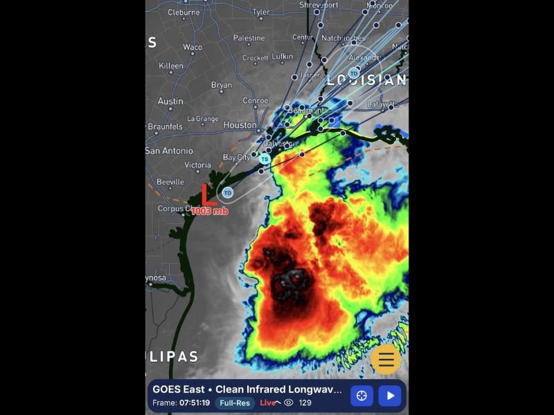
Tropical storm conditions are possible within the watch area and expected within the warning area later today. The GOES-19 infrared satellite imagery shows a large and disorganized but expanding convective mass centered south of Galveston, with the low pressure center at 1003 mb near Corpus Christi tracking northward.
Stay with NapervilleLocal.com for the latest weather updates and local forecast coverage.

I’ve lived in Naperville long enough to see how quickly our community changes — from new developments downtown to sudden shifts in our Midwest weather. Reporting on Naperville news and daily forecasts gives me the chance to keep neighbors informed about what really matters. My goal is simple: deliver clear, timely updates so you always know what’s happening in our city and what to expect from the skies above.