
Strong EF2 Tornadoes Possible Today From Missouri to Illinois and Indiana as Severe Storms Bring Giant Hail and 75 MPH Winds From the High Plains to Ohio Valley
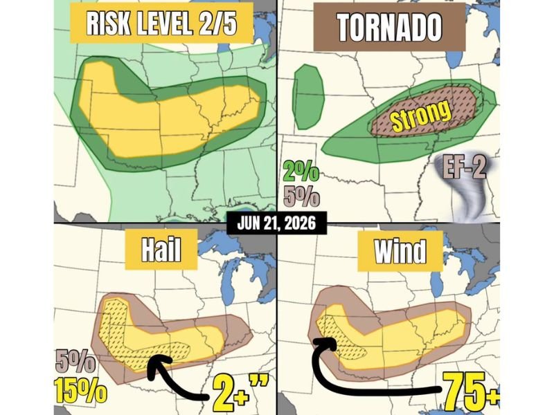
MISSOURI — A widespread severe weather outbreak is expected today across a Risk Level 2 of 5 area stretching from the central High Plains into the Ohio Valley, with the primary tornado threat focused on Missouri, Illinois, and Indiana. Strong tornadoes, potentially reaching EF2 intensity, are possible in association with a morning to early afternoon mesoscale convective vortex.
Forecasters note redevelopment along residual outflows later in the day remains possible, with an upgrade not ruled out if conditions evolve favorably. Across the High Plains, high-based supercells capable of very large hail will also pose a significant threat.
Strong Tornado Corridor Targets Missouri Into Indiana
A enhanced tornado risk, including the potential for strong EF2-rated tornadoes, is highlighted from Missouri through Illinois and into Indiana, carrying a 15 percent tornado probability within that corridor. A broader 5 percent tornado risk surrounds the area, extending the threat across a wider portion of the Ohio Valley region.
High Plains Supercells Bring Giant Hail Threat
Across the High Plains, including the central and southern Plains states, high-based supercell thunderstorms are expected to produce very large hail, with a 15 percent probability of hail two inches in diameter or greater. A tornado cannot be ruled out from these supercells before they congeal into clusters later in the day.
Damaging Wind Threat Builds as Storms Cluster
As supercells merge into broader thunderstorm clusters, the risk for significant straight-line winds increases, with gusts of 75 mph or greater possible across the wind threat zone. This corridor closely follows the hail and tornado risk areas, stretching from the Plains into the Ohio Valley.
Overall Risk Rated 2 Out of 5 for Severe Weather
The overall severe weather risk is categorized at Level 2 of 5, covering a broad area from the central High Plains through the Ohio Valley. Forecasters caution that the exact location of late-day redevelopment remains uncertain, and updates will follow as the setup becomes clearer.
Stay with NapervilleLocal.com for the latest weather updates and local forecast coverage.

I’ve lived in Naperville long enough to see how quickly our community changes — from new developments downtown to sudden shifts in our Midwest weather. Reporting on Naperville news and daily forecasts gives me the chance to keep neighbors informed about what really matters. My goal is simple: deliver clear, timely updates so you always know what’s happening in our city and what to expect from the skies above.