
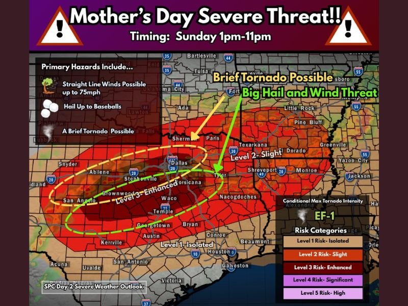
Baseball Sized Hail, 75mph Winds and Tornado Threat Targeting Central Texas Including Dallas, Waco and San Angelo on Mother’s Day Sunday 1PM to 11PM Under Level 3 Enhanced Risk
TEXAS — An active and dangerous severe weather day is setting up across a large portion of Texas on Mother’s Day, Sunday May 10, 2026, with widespread severe thunderstorms appearing likely from 1 PM through 11 PM. The Level 3 Enhanced Risk core covers a broad zone from Abilene and San Angelo through Stephenville, Waco, Temple, and Georgetown, with a Level 2 Slight Risk extending through Dallas, Tyler, Texarkana, and Shreveport. Primary hazards include straight line winds up to 75 mph, baseball sized hail, and a brief tornado possible across the Enhanced Risk corridor.
Baseball Sized Hail and 75mph Winds Greatest Along and South of I-20 Corridor
The wind and hail threat is greatest along and south of the I-20 corridor across central Texas, where the Level 3 Enhanced Risk zone sits. Baseball sized hail and straight line winds reaching 75 mph are the highest confidence hazards across the Waco, Temple, Corsicana, and Nacogdoches corridor through the afternoon and evening hours.
The outflow-dominant storm mode limits the tornado threat somewhat, but a brief EF-1 tornado remains possible given any favorable outflow and storm merger during the active afternoon window.
Storms Fire Through Morning Then Redevelop After Atmosphere Uncaps at Noon to 1PM
Sunday is expected to be an early type severe weather day with storms possible through the morning hours before redeveloping as the atmosphere becomes uncapped by 12 to 1 PM. Large amounts of storm fuel will be available through the afternoon as storms progress southeastward and potentially grow into a large storm complex through the evening hours.
The most intense and organized storm activity is expected during the 1 PM to 11 PM window across the Enhanced and Slight Risk zones.
Level 2 Slight Risk Extends Through Dallas, Tyler and Texarkana Northeast Into Arkansas
The broader Level 2 Slight Risk zone pulls Dallas, Sherman, Paris, Tyler, Texarkana, and Shreveport into the Sunday severe weather picture. Communities across this zone face a meaningful threat for large hail and damaging winds through the afternoon and evening hours as storm complexes push southeastward through the region. Stay with NapervilleLocal.com for the latest weather updates and local forecast coverage.

I’ve lived in Naperville long enough to see how quickly our community changes — from new developments downtown to sudden shifts in our Midwest weather. Reporting on Naperville news and daily forecasts gives me the chance to keep neighbors informed about what really matters. My goal is simple: deliver clear, timely updates so you always know what’s happening in our city and what to expect from the skies above.