
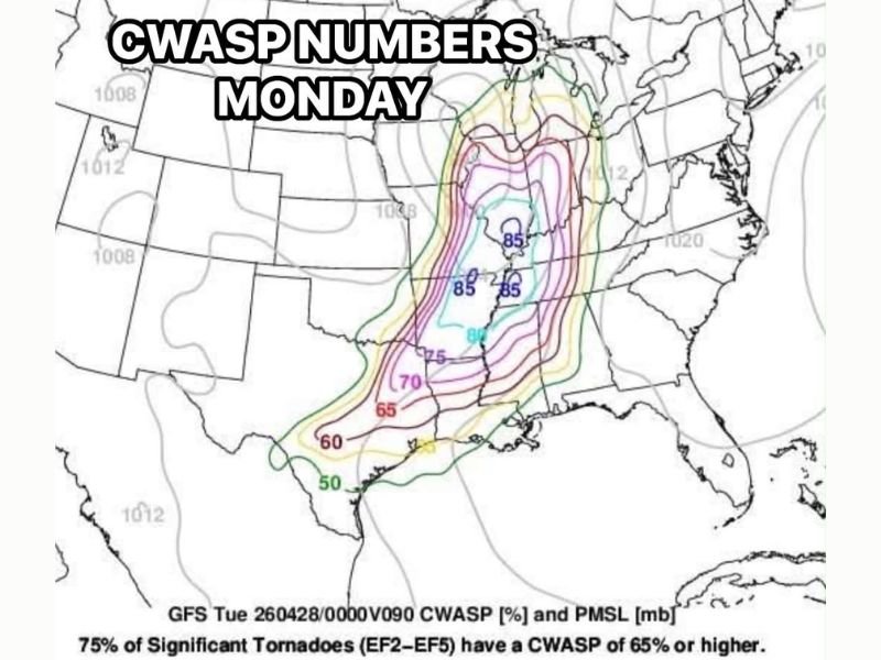
CWASP Numbers Hitting 80-85 Over Southern Illinois and Iowa Monday Raising Significant Tornado Concerns Across the Region
SOUTHERN ILLINOIS AND SURROUNDING REGION — A deeply concerning atmospheric signal is emerging ahead of Monday’s severe weather event, as CWASP numbers are forecast to reach 80-85 across southern Illinois and neighboring areas. This is a significant and alarming threshold given that 75% of all EF2-EF5 tornadoes on record have occurred when CWASP values exceed 65, placing Monday’s setup among the more dangerous atmospheric environments seen across this region in recent memory.
CWASP Values of 80-85 Place Southern Illinois Among Highest Risk Zones Monday
The core of the most elevated CWASP values on Monday sits across southern Illinois and into neighboring Iowa, with the 85 contour appearing in multiple locations across this corridor. These values sit well above the critical 65 threshold that historically correlates with significant and violent tornado production. The broader zone of elevated CWASP numbers stretches across a large footprint covering multiple states, but the southern Illinois region stands out as the area of greatest concern heading into Monday.
Storm Mode Will Be the Critical Factor
The key question forecasters are watching closely heading into Monday is whether storms organize as supercells or consolidate into a squall line. If isolated supercell development occurs, the elevated CWASP environment would support a significant risk for strong to violent tornadoes across the affected corridor. A squall line scenario, by contrast, would lower the tornado threat considerably, though damaging winds would remain a primary hazard in that setup.
Forecasters have noted that much more clarity on storm mode is expected to emerge over the coming 48 hours as the setup comes into better focus across available modeling data.
What CWASP 80-85 Means for Monday’s Threat
CWASP, which measures the atmospheric ingredients favorable for significant tornado production, does not guarantee tornado activity but identifies environments where the atmosphere is capable of supporting violent and long-track tornadoes. Values at or above 80 represent a rare and elevated atmospheric setup that warrants serious attention from residents across southern Illinois, Iowa, and the broader surrounding region well ahead of Monday’s storm window.
Residents across the affected zone should finalize shelter plans, ensure multiple weather alert systems are active, and closely monitor forecast updates over the next 48 hours as storm mode clarity develops and the Monday severe weather threat comes into sharper focus. Stay with NapervilleLocal.com for the latest weather updates and local forecast coverage.

I’ve lived in Naperville long enough to see how quickly our community changes — from new developments downtown to sudden shifts in our Midwest weather. Reporting on Naperville news and daily forecasts gives me the chance to keep neighbors informed about what really matters. My goal is simple: deliver clear, timely updates so you always know what’s happening in our city and what to expect from the skies above.