
Strong to Severe Thunderstorms With 60 MPH Wind Gusts and Small Hail Threatening Indiana Including Fort Wayne, Lafayette, and Indianapolis This Afternoon
INDIANA — A round of strong to potentially severe thunderstorms is expected to develop across a large portion of Indiana this afternoon and evening, with the primary hazard being damaging wind gusts up to 60 mph and small hail possible in the stronger storms. The threat window runs from Noon through 9:00 PM EDT today, April 24, covering a broad geographic footprint from the northern counties near Gary southward through Evansville.
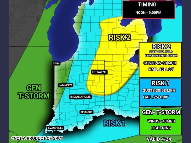
Risk 2 Zone Covers Fort Wayne and Central-Northeast Indiana
The highest concern today sits across a Risk 2 zone covering central and northeastern Indiana, with Fort Wayne at the core of the most elevated threat area. This designation identifies the best area for a strong to severe storm to develop, with wind gusts ranging from 45 to 60 mph and hail between 0.25 and 1.00 inch in diameter possible. Residents across the Fort Wayne corridor and surrounding communities should have preparations in place well before storms arrive this afternoon.
The Risk 2 zone represents the most significant storm threat in today’s outlook and places this portion of Indiana at the highest risk for storm damage across the region.
Risk 1 Zone Stretches Across Remainder of Indiana
A broader Risk 1 area covers much of the rest of Indiana, including communities near Lafayette, Indianapolis, Seymour, and Evansville. Storms across this zone are expected to produce wind gusts between 30 and 58 mph alongside hail up to 1.00 inch. While the threat is lower than the Risk 2 corridor, storms in this zone remain capable of producing wind damage and hail impacts across a wide area of the state.
The Risk 1 zone extends across the southern half of Indiana including the Evansville region, meaning a significant portion of the state faces an elevated storm threat through the evening hours.
No Tornado Threat With Today’s Storm System
Forecasters have confirmed that tornadoes are not expected with today’s storm system. The hazard profile is limited to straight-line wind damage and hail, which removes the most dangerous element from this particular severe weather setup. That said, wind gusts approaching 60 mph are more than capable of downing trees, snapping branches, and causing property damage across affected communities.
Residents across the Risk 1 and Risk 2 zones, particularly near Fort Wayne, Lafayette, and Indianapolis, should stay weather-aware through the evening, move vehicles under cover ahead of the storm window, and monitor local alerts as conditions develop this afternoon. Stay with NapervilleLocal.com for the latest weather updates and local forecast coverage.

I’ve lived in Naperville long enough to see how quickly our community changes — from new developments downtown to sudden shifts in our Midwest weather. Reporting on Naperville news and daily forecasts gives me the chance to keep neighbors informed about what really matters. My goal is simple: deliver clear, timely updates so you always know what’s happening in our city and what to expect from the skies above.