
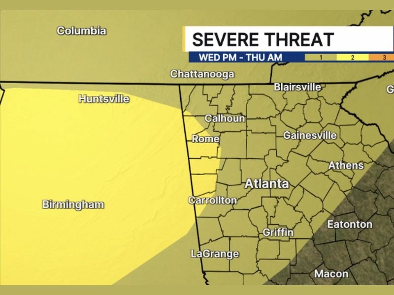
Damaging Wind Gusts, Large Hail and Urban Flash Flooding Targeting West and Northwest Georgia Including Atlanta, Rome and Gainesville Wednesday Night Into Thursday Morning
GEORGIA — Strong to possibly severe storms are moving into west and northwest Georgia late Wednesday, May 6, 2026, continuing through Thursday morning in a threat window that includes damaging wind gusts, large hail, a brief tornado possibility, and urban flash flooding concerns. The severe threat is highest across west and northwest Georgia shown in the brighter yellow zone on the severe threat outlook, covering Atlanta, Rome, Gainesville, Calhoun, Carrollton, and surrounding communities. Damaging wind gusts represent the primary hazard across the entire risk zone.
Damaging Wind Gusts Headline the Severe Threat Across West and Northwest Georgia
The primary severe weather risk for Wednesday night into Thursday morning is damaging wind gusts across west and northwest Georgia. The brighter yellow zone covering Rome, Gainesville, Athens, Calhoun, and the Atlanta metro carries the highest confidence for this hazard.
A brief tornado cannot be completely ruled out, though that risk appears lower at this stage of the forecast. Large hail is also possible with some of the stronger storm cores moving through the region during the overnight hours.
Urban Flash Flooding Risk Thursday Morning Despite Ongoing Drought Conditions
An additional and important risk being monitored is urban flash flooding Thursday morning across Georgia. Although the state remains in drought conditions, rainfall of 1 to 2 inches falling in a short period of time over urban areas is enough to trigger flash flooding in streets, underpasses, and low-lying neighborhoods.
Atlanta, Gainesville, Rome, and surrounding urban communities should be prepared for brief but potentially impactful flash flooding during the Thursday morning hours as the system exits the region.
Broader Risk Zone Extends From Huntsville and Chattanooga Through Macon and Augusta
The full risk zone on the severe threat outlook extends broadly from Huntsville and Chattanooga in the north through Atlanta, Griffin, LaGrange, Eatonton, and Macon southward. Augusta, Greenville, and Blairsville also fall inside the outer threat zone through the Wednesday night into Thursday morning window.
Residents across all communities inside the outlined area should have weather alerts active before going to bed Wednesday night. Stay with NapervilleLocal.com for the latest weather updates and local forecast coverage.

I’ve lived in Naperville long enough to see how quickly our community changes — from new developments downtown to sudden shifts in our Midwest weather. Reporting on Naperville news and daily forecasts gives me the chance to keep neighbors informed about what really matters. My goal is simple: deliver clear, timely updates so you always know what’s happening in our city and what to expect from the skies above.