
Damaging Winds Hail and Isolated Strong Storms Continuing Across Colorado and Surrounding Region With Heat Building Into the 80s and 90s by Thursday
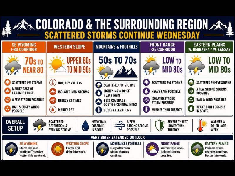
COLORADO AND SURROUNDING REGION — Scattered afternoon and evening thunderstorms will continue across Colorado and the surrounding region Wednesday June 3rd, with a few storms capable of producing damaging winds, hail, and marginally large hail particularly along the Front Range I-25 corridor and eastern plains.
The overall severe threat is lower than Tuesday but not eliminated, with isolated strong storm potential remaining across multiple zones through the afternoon and evening hours. Adding to the pattern, temperatures are set to climb significantly by Thursday with 80s and 90s becoming widespread heading into the weekend.
Front Range and Eastern Plains Carry Isolated Strong Storm Potential Wednesday
The Front Range I-25 corridor and eastern plains of Colorado into western Nebraska and western Kansas are again in line for scattered afternoon thunderstorms Wednesday, with an isolated strong storm possible in each zone. Heavy rain is possible in spots along the Front Range, while hail and gusty winds remain the headline hazards across the eastern plains where temperatures will reach the low to mid 80s. The severe threat is noted as lower than Tuesday but residents across these zones should remain weather-aware through the afternoon hours.
Mountains and Foothills See Best Storm Coverage With Lightning and Heavy Rain
The mountains and foothills carry the best overall storm coverage Wednesday, with scattered afternoon convection producing lightning, brief heavy rain, and gusty winds near storm cells across the south and central mountain zones. Temperatures across the higher elevations will remain in the 50s to 70s, keeping conditions cooler than the plains but active through the afternoon. The western slope will stay hot and mainly dry with upper 80s to mid 90s and only isolated mountain storm chances.
Heat Builds Into the 80s and 90s by Thursday Through the Weekend
A significant pattern shift is incoming as temperatures ramp up across the western slope and eastern plains into the 80s and 90s by Thursday, with the heat persisting through the weekend and into next week. Storm coverage may diminish temporarily as the heat core builds before picking back up again next week. Thunderstorms developing within this intense heat will carry an elevated risk of strong outflow boundary winds and microbursts on any day storms are in the forecast.
Stay with NapervilleLocal.com for the latest weather updates and local forecast coverage.

I’ve lived in Naperville long enough to see how quickly our community changes — from new developments downtown to sudden shifts in our Midwest weather. Reporting on Naperville news and daily forecasts gives me the chance to keep neighbors informed about what really matters. My goal is simple: deliver clear, timely updates so you always know what’s happening in our city and what to expect from the skies above.